
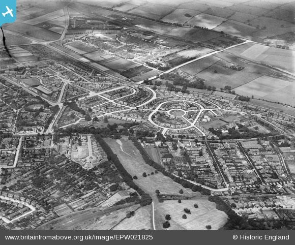
EPW021825 ENGLAND (1928). Collin Green and surroundings, Sherwood, 1928
© Hawlfraint cyfranwyr OpenStreetMap a thrwyddedwyd gan yr OpenStreetMap Foundation. 2026. Trwyddedir y gartograffeg fel CC BY-SA.
Delweddau cyfagos (5)
EPW021825

 0°
0m
0°
0m
EPW021824
 17°
50m
17°
50m
EPW021827
 203°
89m
203°
89m
EPW021828
 213°
144m
213°
144m
EPW021826
 210°
154m
210°
154m
Manylion
| Pennawd | [EPW021825] Collin Green and surroundings, Sherwood, 1928 |
| Cyfeirnod | EPW021825 |
| Dyddiad | June-1928 |
| Dolen | |
| Enw lle | SHERWOOD |
| Plwyf | |
| Ardal | |
| Gwlad | ENGLAND |
| Dwyreiniad / Gogleddiad | 457524, 343688 |
| Hydred / Lledred | -1.1430084137628, 52.98712718218 |
| Cyfeirnod Grid Cenedlaethol | SK575437 |
Pinnau
 City Hospital
Cyfraniadau Grŵp
This is one of several "Nottingham" views which show the Nottingham Suburban Railway (NSR. At this time (June 1928) it was still a two track main line. The line can be seen at the bottom of the picture about an inch up passing through Woodthorpe Park. The white vertical line, centre bottom, is the drive which goes to the Woodthorpe Grange (out of shot at bottom of picture) and where it passes between the two rows of trees, the railway passes underneath using Ashwell's Tunnel. To the left of Ashwell's tunnel the line opens out to enter Sherwood Station , whose goods yard can be seen bottom left. To the right of Woodthorpe Park the NSR passed under Scout Lane (now Woodthorpe Drive) and passed between houses on its way north to Daybrook Junction. |

NSR1889 |
Monday 27th of August 2012 09:38:31 PM |