
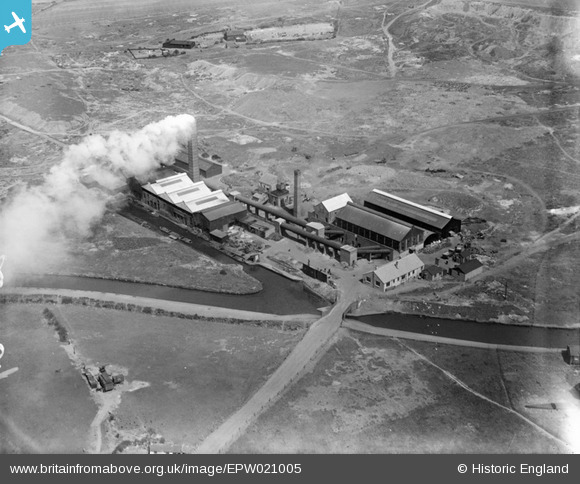
EPW021005 ENGLAND (1928). James Bridge Copper Works, Pleck, 1928
© Hawlfraint cyfranwyr OpenStreetMap a thrwyddedwyd gan yr OpenStreetMap Foundation. 2026. Trwyddedir y gartograffeg fel CC BY-SA.
Delweddau cyfagos (10)
EPW021005

EPW021004

EAW017759

EAW017762

EAW017761

EAW017764

EAW017765

EAW017760

EAW017766

EAW017763

Manylion
| Pennawd | [EPW021005] James Bridge Copper Works, Pleck, 1928 |
| Cyfeirnod | EPW021005 |
| Dyddiad | April-1928 |
| Dolen | |
| Enw lle | PLECK |
| Plwyf | |
| Ardal | |
| Gwlad | ENGLAND |
| Dwyreiniad / Gogleddiad | 399314, 297735 |
| Hydred / Lledred | -2.0101242984919, 52.577072592125 |
| Cyfeirnod Grid Cenedlaethol | SO993977 |
Pinnau

Michelle L Spinks |
Saturday 30th of March 2013 12:51:51 PM |
Cyfraniadau Grŵp
This site would be almost unrecognisable to modern eyes. The works are gone and completely covered with concrete. All that remains is the narrow Spinks Bridge and part of the spur, now closed off the narrowest point near the junction. The road leading up to works is still present and jinks back to the right to connect to Darlaston Road out of shot. Nowadays the M6 would run vertically just of the left hand side of the shot. With Alumwell all still fields Woodwards Road and Primley Avenue would probably be in shot in the top right hand corner. It may be an optical illusion but the land does appear to rise towards what would be Jerome Road / Southbourne Avenue right in the top corner. I am intrigued by the two isolated buildings towards the top left where the present day schools would be. |
K S Clark |
Tuesday 28th of March 2017 08:48:41 AM |
Hi, do you have any information on the history of Spinks Bridge? I share the same surname and was born in the area. My family had lived in Walsall for a very long time and I'm interested in seeing if there was a connection to the family name. |
Michelle L Spinks |
Saturday 30th of March 2013 12:59:14 PM |
For further clarification see: The Godfrey Edition of the Old Ordnance Survey Maps; Walsall (SW) & Pleck 1901)... I surmise the buildings (as shown on the map) belong to the former James Bridge Colliery which seems to extend over the whole site including the former brick works; which too, sits in the same area as the former copper works. Furthermore, the topography of the land is affected by the gravel pit and I would imagine possibly from mining spoil. I was brought up in Pleck on the post wars council housing estates on land which extends from the former Colliery site to the Park Farm (shown on the map). There are significant and abrupt changes in gradient which I feel does correlate with the land rises you describe. A walk about the housing area with old and new maps would make sense. Hope this helps. |
Michelle L Spinks |
Tuesday 28th of March 2017 08:48:41 AM |

BCN Walsall canal |
Martin |
Saturday 30th of March 2013 12:55:49 PM |
Hi, do you have any information on the history of Spinks Bridge? ... I share the family name and my family had lived in the area a very long time. Many thanks |
Michelle L Spinks |
Saturday 30th of March 2013 12:55:49 PM |