
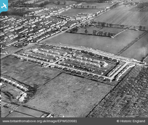
EPW020681 ENGLAND (1928). New housing development around Hunters Grove, Hayes Town, 1928
© Hawlfraint cyfranwyr OpenStreetMap a thrwyddedwyd gan yr OpenStreetMap Foundation. 2026. Trwyddedir y gartograffeg fel CC BY-SA.
Delweddau cyfagos (3)
EPW020681

EPW020682

EPW034900

Manylion
| Pennawd | [EPW020681] New housing development around Hunters Grove, Hayes Town, 1928 |
| Cyfeirnod | EPW020681 |
| Dyddiad | March-1928 |
| Dolen | |
| Enw lle | HAYES TOWN |
| Plwyf | |
| Ardal | |
| Gwlad | ENGLAND |
| Dwyreiniad / Gogleddiad | 510309, 180038 |
| Hydred / Lledred | -0.41034793176661, 51.508009050431 |
| Cyfeirnod Grid Cenedlaethol | TQ103800 |
Pinnau

Brian |
Thursday 22nd of February 2018 11:45:38 PM | |
|
houds |
Wednesday 28th of October 2015 07:41:29 AM | |
|
Brian |
Thursday 5th of February 2015 11:38:15 PM | |
|
Brian |
Thursday 5th of February 2015 11:37:24 PM | |
|
Cupcakes |
Wednesday 13th of November 2013 08:29:36 PM | |
|
John Russell |
Friday 13th of July 2012 02:29:16 PM |
Cyfraniadau Grŵp
This shot is looking north. The main housing development in the photograph is the GWR Estate. Closest to the camera is Hunter's Grove and furthest north is Minet Drive, still under construction (not yet built but at 19 Minet Drive is where the Abbott family lived for some 50 years). Right are the orchards used by Howell & Hall bakery in making their apple pies, althought their factory does not appear in the photograph. Running north-south is Coldharbour Lane and the crescent is East Holme. Opposite is the Minet farm. |
Mike |
Friday 6th of July 2012 03:50:33 PM |