
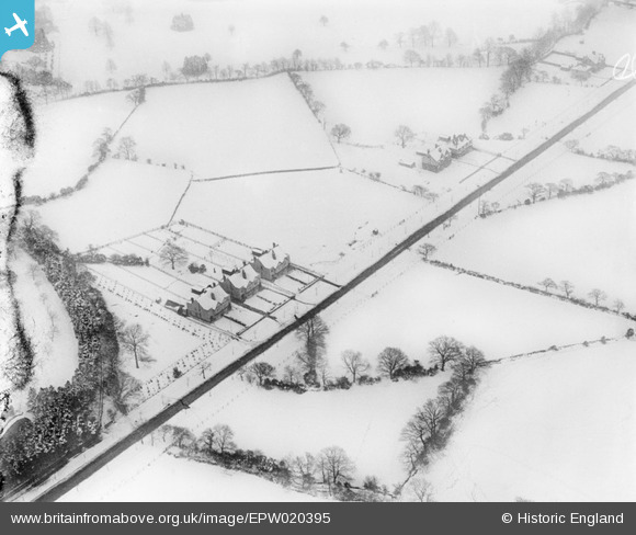
EPW020395 ENGLAND (1928). Housing in the snow around Whirlowdale Road, Whirlow, 1928
© Hawlfraint cyfranwyr OpenStreetMap a thrwyddedwyd gan yr OpenStreetMap Foundation. 2026. Trwyddedir y gartograffeg fel CC BY-SA.
Delweddau cyfagos (10)
EPW020395

EPW020393

EPW020392

EAW042401

EAW042404
, Whirlow, 1952. This image has been produced from a damaged negative.")
EAW042407

EAW042403
, Whirlow, 1952. This image has been produced from a damaged negative.")
EAW042402

EAW042405

EAW042408

Manylion
| Pennawd | [EPW020395] Housing in the snow around Whirlowdale Road, Whirlow, 1928 |
| Cyfeirnod | EPW020395 |
| Dyddiad | March-1928 |
| Dolen | |
| Enw lle | WHIRLOW |
| Plwyf | |
| Ardal | |
| Gwlad | ENGLAND |
| Dwyreiniad / Gogleddiad | 431698, 382708 |
| Hydred / Lledred | -1.5238772175483, 53.340054294764 |
| Cyfeirnod Grid Cenedlaethol | SK317827 |
Pinnau

totoro |
Sunday 12th of January 2014 03:34:50 PM | |
|
totoro |
Sunday 12th of January 2014 02:47:59 PM | |
|
totoro |
Sunday 12th of January 2014 02:47:14 PM | |
|
totoro |
Sunday 12th of January 2014 02:45:59 PM |
Cyfraniadau Grŵp
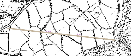
Portion of Ordnance Survey Epoch 1 map of the area (Yorkshire 298) 1854, with the road added as a straight line and the five flagged houses on as pink dots. The curve to the left of the bottom houses appears to be a field road. (Crown Copyright. Published 1854. Subject to The Copyright, Designs and Patents Act 1988 (c.48) Part 1 Chapter X (163) ) |
totoro |
Sunday 12th of January 2014 03:29:15 PM |