
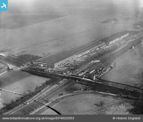
EPW020353 ENGLAND (1928). British Industries Fair Exhibition Hall, Castle Bromwich, from the south-west, 1928
© Hawlfraint cyfranwyr OpenStreetMap a thrwyddedwyd gan yr OpenStreetMap Foundation. 2026. Trwyddedir y gartograffeg fel CC BY-SA.
Delweddau cyfagos (20)
EPW020353

EPW020346

EPW020346
EPW020347

EPW020345

EPW020350

EPW020349

EPW020348

EPW020351

EPW020352

EPW020352
EAW015287

EPW007488

EAW015284

EAW015278

EAW014405

EAW014403

EPW042879

EAW043039

EPW042880

Manylion
| Pennawd | [EPW020353] British Industries Fair Exhibition Hall, Castle Bromwich, from the south-west, 1928 |
| Cyfeirnod | EPW020353 |
| Dyddiad | 28-February-1928 |
| Dolen | |
| Enw lle | CASTLE BROMWICH |
| Plwyf | |
| Ardal | |
| Gwlad | ENGLAND |
| Dwyreiniad / Gogleddiad | 413835, 290383 |
| Hydred / Lledred | -1.7961239960909, 52.510796251661 |
| Cyfeirnod Grid Cenedlaethol | SP138904 |
Pinnau

Billy Turner |
Tuesday 18th of October 2016 05:30:50 PM | |

Steve Cemm |
Friday 6th of July 2012 04:14:12 PM | |
|
Steve Cemm |
Friday 6th of July 2012 04:13:31 PM | |
I don't think it is the racecourse, which was fully up and running in 1928 (from 1896), no stands, rails etc visible, and had hill behind it. |
Willocolt |
Friday 6th of July 2012 09:48:42 PM |
Almost. Early maps show a loop of the course reaching near to this point which, run clockwise, led to the start of the of the one mile straight back to the grandstands. Later maps only show the straight so presumably the course was remodelled at some time. |
gerry-r |
Saturday 3rd of January 2015 09:08:18 PM |
|
Roy Cousins |
Wednesday 27th of June 2012 11:50:52 AM |
