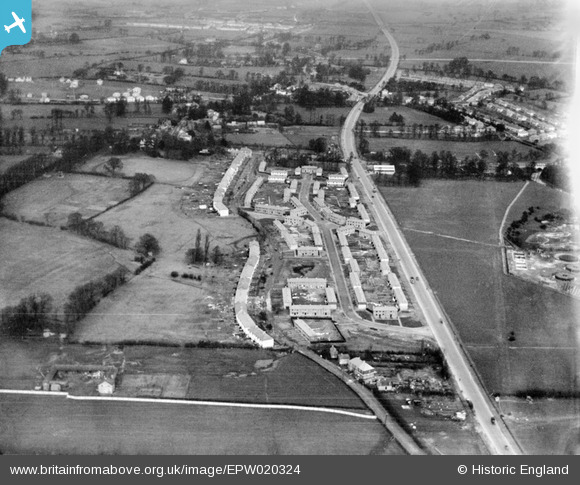
EPW020324 ENGLAND (1928). New housing at Stanhope Road, Greenford, from the south-west, 1928
© Hawlfraint cyfranwyr OpenStreetMap a thrwyddedwyd gan yr OpenStreetMap Foundation. 2026. Trwyddedir y gartograffeg fel CC BY-SA.
Delweddau cyfagos (8)
Manylion
| Pennawd | [EPW020324] New housing at Stanhope Road, Greenford, from the south-west, 1928 |
| Cyfeirnod | EPW020324 |
| Dyddiad | February-1928 |
| Dolen | |
| Enw lle | GREENFORD |
| Plwyf | |
| Ardal | |
| Gwlad | ENGLAND |
| Dwyreiniad / Gogleddiad | 514205, 181771 |
| Hydred / Lledred | -0.35366593467972, 51.52281246376 |
| Cyfeirnod Grid Cenedlaethol | TQ142818 |
Pinnau

GaryW |
Thursday 24th of March 2022 02:29:10 PM | |

Des Elmes |
Thursday 14th of April 2016 04:46:04 PM | |

Des Elmes |
Tuesday 5th of April 2016 01:24:02 AM | |

Des Elmes |
Tuesday 5th of April 2016 01:20:59 AM | |

Des Elmes |
Tuesday 5th of April 2016 01:20:37 AM |


![[EPW020324] New housing at Stanhope Road, Greenford, from the south-west, 1928](http://britainfromabove.org.uk/sites/all/libraries/aerofilms-images/public/100x100/EPW/020/EPW020324.jpg)
![[EPW020329] New housing at Stanhope Road, Greenford, 1928](http://britainfromabove.org.uk/sites/all/libraries/aerofilms-images/public/100x100/EPW/020/EPW020329.jpg)
![[EPW020325] New housing off Greenford Road and Sewage Works, Greenford, 1928](http://britainfromabove.org.uk/sites/all/libraries/aerofilms-images/public/100x100/EPW/020/EPW020325.jpg)
![[EPW020326] New housing off Greenford Road and Sewage Works, Greenford, 1928](http://britainfromabove.org.uk/sites/all/libraries/aerofilms-images/public/100x100/EPW/020/EPW020326.jpg)
![[EPW020327] New housing at Stanhope Road, Greenford, 1928](http://britainfromabove.org.uk/sites/all/libraries/aerofilms-images/public/100x100/EPW/020/EPW020327.jpg)
![[EPW020330] New housing at Stanhope Road, Greenford, 1928](http://britainfromabove.org.uk/sites/all/libraries/aerofilms-images/public/100x100/EPW/020/EPW020330.jpg)