
EPW019789 ENGLAND (1927). Coast Road, Wallsend, 1927

© Hawlfraint cyfranwyr OpenStreetMap a thrwyddedwyd gan yr OpenStreetMap Foundation. 2026. Trwyddedir y gartograffeg fel CC BY-SA.
Delweddau cyfagos (2)
EPW019789

EPW019791

Manylion
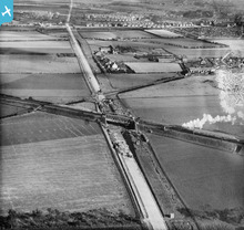
| Pennawd | [EPW019789] Coast Road, Wallsend, 1927 |
| Cyfeirnod | EPW019789 |
| Dyddiad | 20-October-1927 |
| Dolen | |
| Enw lle | WALLSEND |
| Plwyf | |
| Ardal | |
| Gwlad | ENGLAND |
| Dwyreiniad / Gogleddiad | 428237, 566904 |
| Hydred / Lledred | -1.5585813076125, 54.995841512436 |
| Cyfeirnod Grid Cenedlaethol | NZ282669 |
Pinnau

derekcordes |
Thursday 29th of September 2016 09:46:02 AM | |
|
chris lowery |
Wednesday 4th of September 2013 05:25:19 PM | |
This section was used by Tyneside Tramways & Tramroads Co as their route between Wallsend and Gosforth.Opened 18/10/1902 and closed 6/4/1930. |
mannidaze |
Sunday 25th of October 2015 04:43:47 PM |
|
chris lowery |
Wednesday 4th of September 2013 05:23:01 PM | |
|
chris lowery |
Wednesday 4th of September 2013 05:21:47 PM | |
|
Eddy Liiddell |
Friday 14th of June 2013 08:16:08 PM | |
|
MB |
Saturday 13th of October 2012 02:10:42 PM | |
|
Eric Hollerton |
Thursday 23rd of August 2012 08:09:03 PM |
Cyfraniadau Grŵp
Coast Road wallsend. |
hellraiser |
Sunday 16th of March 2014 08:29:06 AM |
Wills Factory built in 1950s |
Oldheaton |
Sunday 21st of July 2013 12:53:54 AM |
Railway bridge over the Coast Road is the East Coast main line,and is the boundary between Newcastle and Wallsend(North Tyneside) |
Stuart |
Tuesday 26th of June 2012 02:13:37 PM |