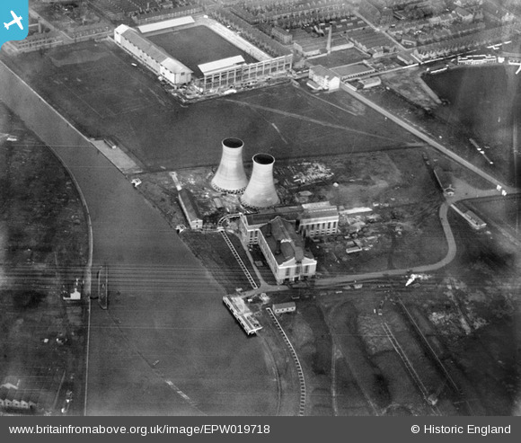
EPW019718 ENGLAND (1927). Power Station at Freeman's Wharf (now the site of the King Power Stadium), Leicester, 1927
© Hawlfraint cyfranwyr OpenStreetMap a thrwyddedwyd gan yr OpenStreetMap Foundation. 2026. Trwyddedir y gartograffeg fel CC BY-SA.
Delweddau cyfagos (17)
Manylion
| Pennawd | [EPW019718] Power Station at Freeman's Wharf (now the site of the King Power Stadium), Leicester, 1927 |
| Cyfeirnod | EPW019718 |
| Dyddiad | October-1927 |
| Dolen | |
| Enw lle | LEICESTER |
| Plwyf | |
| Ardal | |
| Gwlad | ENGLAND |
| Dwyreiniad / Gogleddiad | 458140, 302981 |
| Hydred / Lledred | -1.1410739747739, 52.621125308811 |
| Cyfeirnod Grid Cenedlaethol | SK581030 |
Pinnau

Class31 |
Sunday 10th of February 2013 05:54:55 PM | |

Class31 |
Sunday 10th of February 2013 05:52:54 PM | |

Class31 |
Sunday 10th of February 2013 05:51:33 PM | |
The double deck South Stand under construction. |

gBr |
Saturday 29th of November 2014 12:42:05 AM |

Class31 |
Sunday 10th of February 2013 05:46:55 PM |


![[EPW019718] Power Station at Freeman's Wharf (now the site of the King Power Stadium), Leicester, 1927](http://britainfromabove.org.uk/sites/all/libraries/aerofilms-images/public/100x100/EPW/019/EPW019718.jpg)
![[EPW019717] Power Station at Freeman's Wharf (now the site of the King Power Stadium), Leicester, 1927](http://britainfromabove.org.uk/sites/all/libraries/aerofilms-images/public/100x100/EPW/019/EPW019717.jpg)
![[EPW019720] Power Station at Freeman's Wharf (now the site of the King Power Stadium) and environs, Leicester, 1927](http://britainfromabove.org.uk/sites/all/libraries/aerofilms-images/public/100x100/EPW/019/EPW019720.jpg)
![[EPW019716] Power Station at Freeman's Wharf (now the site of the King Power Stadium), Leicester, 1927](http://britainfromabove.org.uk/sites/all/libraries/aerofilms-images/public/100x100/EPW/019/EPW019716.jpg)
![[EPW019719] Power Station at Freeman's Wharf (now the site of the King Power Stadium) and environs, Leicester, 1927](http://britainfromabove.org.uk/sites/all/libraries/aerofilms-images/public/100x100/EPW/019/EPW019719.jpg)
![[EAW001143] The A.W. Swann & Co Ltd Hosiery Works and South Leicester Working Mens Club on Burnmoor Street and the Raw Dykes Power Station, Leicester, 1946](http://britainfromabove.org.uk/sites/all/libraries/aerofilms-images/public/100x100/EAW/001/EAW001143.jpg)
![[EAW001136] The A.W. Swann & Co Ltd Hosiery Works and South Leicester Working Mens Club on Burnmoor Street and the Raw Dykes Power Station, Leicester, 1946](http://britainfromabove.org.uk/sites/all/libraries/aerofilms-images/public/100x100/EAW/001/EAW001136.jpg)
![[EAW001140] The A.W. Swann & Co Ltd Hosiery Works and South Leicester Working Mens Club on Burnmoor Street and the Raw Dykes Power Station, Leicester, 1946](http://britainfromabove.org.uk/sites/all/libraries/aerofilms-images/public/100x100/EAW/001/EAW001140.jpg)
![[EPW021006] Electrical Power Station and Agricultural Show Ground, Leicester, from the north-west, 1928](http://britainfromabove.org.uk/sites/all/libraries/aerofilms-images/public/100x100/EPW/021/EPW021006.jpg)
![[EAW001137] The A.W. Swann & Co Ltd Hosiery Works and South Leicester Working Mens Club on Burnmoor Street and the Raw Dykes Power Station, Leicester, 1946](http://britainfromabove.org.uk/sites/all/libraries/aerofilms-images/public/100x100/EAW/001/EAW001137.jpg)
![[EAW001142] The A.W. Swann & Co Ltd Hosiery Works and South Leicester Working Mens Club on Burnmoor Street, Leicester, 1946](http://britainfromabove.org.uk/sites/all/libraries/aerofilms-images/public/100x100/EAW/001/EAW001142.jpg)
![[EAW001138] The A.W. Swann & Co Ltd Hosiery Works and South Leicester Working Mens Club on Burnmoor Street, Leicester, 1946](http://britainfromabove.org.uk/sites/all/libraries/aerofilms-images/public/100x100/EAW/001/EAW001138.jpg)
![[EAW001141] The A.W. Swann & Co Ltd Hosiery Works and South Leicester Working Mens Club on Burnmoor Street and the Raw Dykes Power Station, Leicester, 1946](http://britainfromabove.org.uk/sites/all/libraries/aerofilms-images/public/100x100/EAW/001/EAW001141.jpg)
![[EAW001139] The A.W. Swann & Co Ltd Hosiery Works and South Leicester Working Mens Club on Burnmoor Street, Leicester, 1946](http://britainfromabove.org.uk/sites/all/libraries/aerofilms-images/public/100x100/EAW/001/EAW001139.jpg)
![[EPW008511] Leicester City Football Ground and the County Cricket Ground, Leicester, 1923](http://britainfromabove.org.uk/sites/all/libraries/aerofilms-images/public/100x100/EPW/008/EPW008511.jpg)
![[EPW047635] Leicester Corporation Gas Works and environs, Leicester, from the north, 1935](http://britainfromabove.org.uk/sites/all/libraries/aerofilms-images/public/100x100/EPW/047/EPW047635.jpg)
![[EAW045099] The Komet Hosiery Machine Works and environs, Leicester, 1952. This image was marked by Aerofilms Ltd for photo editing.](http://britainfromabove.org.uk/sites/all/libraries/aerofilms-images/public/100x100/EAW/045/EAW045099.jpg)