
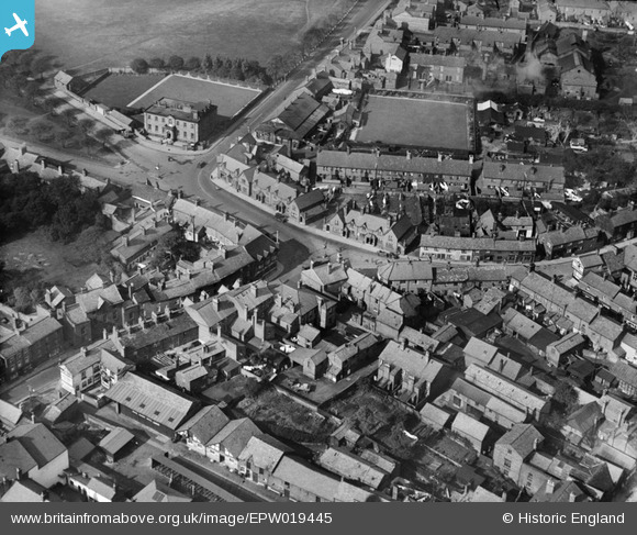
EPW019445 ENGLAND (1927). The junction of Tatton Street, Princess Street and Canute Place, Knutsford, 1927
© Hawlfraint cyfranwyr OpenStreetMap a thrwyddedwyd gan yr OpenStreetMap Foundation. 2025. Trwyddedir y gartograffeg fel CC BY-SA.
Delweddau cyfagos (6)
EPW019445

EAW050495

EPW019446

EAW050497

EPW019443

EPW019447

Manylion
| Pennawd | [EPW019445] The junction of Tatton Street, Princess Street and Canute Place, Knutsford, 1927 |
| Cyfeirnod | EPW019445 |
| Dyddiad | October-1927 |
| Dolen | |
| Enw lle | KNUTSFORD |
| Plwyf | KNUTSFORD |
| Ardal | |
| Gwlad | ENGLAND |
| Dwyreiniad / Gogleddiad | 375065, 378742 |
| Hydred / Lledred | -2.3742291512132, 53.304763837973 |
| Cyfeirnod Grid Cenedlaethol | SJ751787 |
Pinnau

stardelta |
Saturday 2nd of August 2014 10:42:12 PM | |
|
stardelta |
Saturday 2nd of August 2014 10:40:59 PM | |
|
GinnyC |
Sunday 31st of March 2013 07:46:51 PM | |
|
GinnyC |
Sunday 31st of March 2013 07:46:12 PM | |
|
GinnyC |
Sunday 31st of March 2013 07:45:17 PM | |
|
GinnyC |
Sunday 31st of March 2013 07:44:27 PM | |
|
GinnyC |
Sunday 31st of March 2013 07:43:53 PM | |
|
GinnyC |
Sunday 31st of March 2013 07:41:59 PM | |
|
GinnyC |
Sunday 31st of March 2013 07:41:29 PM | |
|
GinnyC |
Sunday 31st of March 2013 07:38:14 PM | |
This is where they used to have horse races for 200 years, up to the mid-1800s |
GinnyC |
Sunday 31st of March 2013 07:40:15 PM |
|
GinnyC |
Sunday 31st of March 2013 07:36:28 PM |