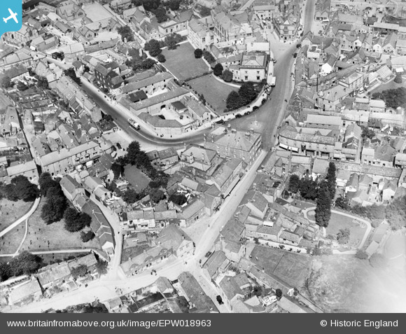
EPW018963 ENGLAND (1927). The town centre, Bakewell, 1927
© Hawlfraint cyfranwyr OpenStreetMap a thrwyddedwyd gan yr OpenStreetMap Foundation. 2026. Trwyddedir y gartograffeg fel CC BY-SA.
Delweddau cyfagos (11)
Manylion
| Pennawd | [EPW018963] The town centre, Bakewell, 1927 |
| Cyfeirnod | EPW018963 |
| Dyddiad | July-1927 |
| Dolen | |
| Enw lle | BAKEWELL |
| Plwyf | BAKEWELL |
| Ardal | |
| Gwlad | ENGLAND |
| Dwyreiniad / Gogleddiad | 421714, 368475 |
| Hydred / Lledred | -1.6748121115064, 53.212608638887 |
| Cyfeirnod Grid Cenedlaethol | SK217685 |
Pinnau

pip |
Sunday 24th of March 2024 06:00:26 PM | |

melgibbs |
Tuesday 12th of August 2014 07:19:58 PM | |

MB |
Wednesday 10th of October 2012 10:46:14 AM | |

MB |
Wednesday 10th of October 2012 10:44:37 AM | |

MB |
Wednesday 10th of October 2012 10:44:12 AM | |

MB |
Wednesday 10th of October 2012 10:42:53 AM | |

MB |
Wednesday 10th of October 2012 10:42:06 AM | |

MB |
Wednesday 10th of October 2012 10:41:39 AM | |

MB |
Wednesday 10th of October 2012 10:39:25 AM | |

MB |
Wednesday 10th of October 2012 10:39:04 AM | |

MB |
Wednesday 10th of October 2012 10:38:33 AM | |

MB |
Wednesday 10th of October 2012 10:37:56 AM | |

MB |
Wednesday 10th of October 2012 10:37:05 AM | |

MB |
Wednesday 10th of October 2012 10:36:21 AM |


![[EPW018963] The town centre, Bakewell, 1927](http://britainfromabove.org.uk/sites/all/libraries/aerofilms-images/public/100x100/EPW/018/EPW018963.jpg)
![[EAW016079] Rutland Square, Bakewell, 1948. This image has been produced from a print marked by Aerofilms Ltd for photo editing.](http://britainfromabove.org.uk/sites/all/libraries/aerofilms-images/public/100x100/EAW/016/EAW016079.jpg)
![[EAW016081] Rutland Square, Bakewell, 1948. This image has been produced from a print marked by Aerofilms Ltd for photo editing.](http://britainfromabove.org.uk/sites/all/libraries/aerofilms-images/public/100x100/EAW/016/EAW016081.jpg)
![[EAW016082] The town centre, Bakewell, 1948. This image has been produced from a print marked by Aerofilms Ltd for photo editing.](http://britainfromabove.org.uk/sites/all/libraries/aerofilms-images/public/100x100/EAW/016/EAW016082.jpg)
![[EPW018962] The town centre, Bakewell, 1927](http://britainfromabove.org.uk/sites/all/libraries/aerofilms-images/public/100x100/EPW/018/EPW018962.jpg)
![[EPW018967] Rutland Square, Bakewell, 1927](http://britainfromabove.org.uk/sites/all/libraries/aerofilms-images/public/100x100/EPW/018/EPW018967.jpg)
![[EAW016083] The town centre, Bakewell, 1948. This image has been produced from a print marked by Aerofilms Ltd for photo editing.](http://britainfromabove.org.uk/sites/all/libraries/aerofilms-images/public/100x100/EAW/016/EAW016083.jpg)
![[EAW016084] Rutland Square, Bakewell, 1948. This image has been produced from a print marked by Aerofilms Ltd for photo editing.](http://britainfromabove.org.uk/sites/all/libraries/aerofilms-images/public/100x100/EAW/016/EAW016084.jpg)
![[EPW018965] All Saints' Church and the town centre, Bakewell, 1927](http://britainfromabove.org.uk/sites/all/libraries/aerofilms-images/public/100x100/EPW/018/EPW018965.jpg)
![[EAW016080] Rutland Square, Bakewell, 1948. This image has been produced from a print marked by Aerofilms Ltd for photo editing.](http://britainfromabove.org.uk/sites/all/libraries/aerofilms-images/public/100x100/EAW/016/EAW016080.jpg)
![[EPW018966] All Saints' Church, Bakewell, 1927. This image has been produced from a print affected by flare.](http://britainfromabove.org.uk/sites/all/libraries/aerofilms-images/public/100x100/EPW/018/EPW018966.jpg)