
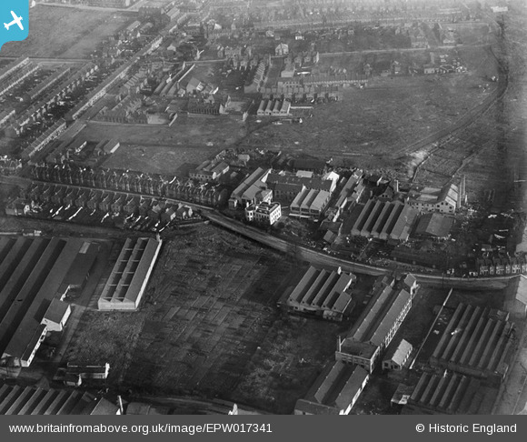
EPW017341 ENGLAND (1926). Baird & Tatlock's Scientific Instrument Factory and environs, Walthamstow, 1926
© Hawlfraint cyfranwyr OpenStreetMap a thrwyddedwyd gan yr OpenStreetMap Foundation. 2026. Trwyddedir y gartograffeg fel CC BY-SA.
Delweddau cyfagos (38)
EPW017341

EPW017339

EPW017337

EPW017338

EPW017340

EPW017344

EPW037541

EAW025748

EPW037544

EPW037545

EPW037543

EPW037919

EPW037546

EPW037540

EPW037922

EPW037547

EPW037921

EPW037918

EPW037920

EPW037542

EAW035357

EAW025752

EAW025746

EAW035350

EAW035351

EAW035349

EAW025753

EPW037925

EAW035353

EAW025749

EAW035352

EPW037926

EAW035359

EAW025751

EPW037923

EAW025747

EAW035358

EPW037927

Manylion
| Pennawd | [EPW017341] Baird & Tatlock's Scientific Instrument Factory and environs, Walthamstow, 1926 |
| Cyfeirnod | EPW017341 |
| Dyddiad | 8-December-1926 |
| Dolen | |
| Enw lle | WALTHAMSTOW |
| Plwyf | |
| Ardal | |
| Gwlad | ENGLAND |
| Dwyreiniad / Gogleddiad | 535885, 189859 |
| Hydred / Lledred | -0.038190818414434, 51.590700036609 |
| Cyfeirnod Grid Cenedlaethol | TQ359899 |
Pinnau

Dank |
Friday 8th of May 2020 07:28:57 PM |
Cyfraniadau Grŵp
Based on Image 017340 a good reference point is the track which appears just behind the factory and runs to the right and upwards. This is the outline of Sutherland Road which joins St Andrews Road (left) and exits near Higham Street (top right). Based on Image 017341 just towards the top Left corner (along St Andrews Road) on the righthand side of that is Higham Hill Primary School. You can just pick out (zooming in) the gate pillars, the main school building, the playground and rain canopy - typical of early 1900's Board Schools and a further school building to the right all enclosed by usual 5 foot brick walling. The factory sheds that appear in the bottom right corner belong to the Micanite & Insulator's works(Hooker Road). Here they made and perfected 'Tego' Gluefilm, a top secret preparation that coated the fuselage of some of Britain's WW2 fighter planes. There used to be the works nameplate painted black on yellow (8 foot x 2 foot)on the flank wall of Hooker Road off Blackhorse Lane, but somebody pinched that around about 1992. |
 8-2007.JPG)
Keith |
Saturday 30th of June 2012 10:56:42 AM |