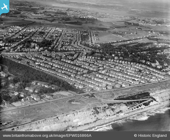
EPW016866A ENGLAND (1926). Southbourne Overcliff Drive and residential area, West Southbourne, from the south-west, 1926
© Hawlfraint cyfranwyr OpenStreetMap a thrwyddedwyd gan yr OpenStreetMap Foundation. 2025. Trwyddedir y gartograffeg fel CC BY-SA.
Delweddau cyfagos (2)
EPW016866A

EPW018178

Manylion
| Pennawd | [EPW016866A] Southbourne Overcliff Drive and residential area, West Southbourne, from the south-west, 1926 |
| Cyfeirnod | EPW016866A |
| Dyddiad | August-1926 |
| Dolen | |
| Enw lle | WEST SOUTHBOURNE |
| Plwyf | |
| Ardal | |
| Gwlad | ENGLAND |
| Dwyreiniad / Gogleddiad | 413058, 91438 |
| Hydred / Lledred | -1.8149940781776, 50.721846031143 |
| Cyfeirnod Grid Cenedlaethol | SZ131914 |
Pinnau

kath |
Thursday 17th of September 2020 04:33:40 PM | |

Class31 |
Tuesday 15th of July 2014 09:03:21 AM | |
|
divingdave |
Monday 16th of June 2014 07:59:55 PM | |
|
JonWalker |
Sunday 21st of October 2012 09:59:08 AM | |
|
JonWalker |
Sunday 21st of October 2012 09:57:43 AM | |
|
JonWalker |
Sunday 21st of October 2012 09:57:11 AM | |
|
JonWalker |
Sunday 21st of October 2012 09:56:35 AM | |
|
JonWalker |
Sunday 21st of October 2012 09:36:58 AM | |
|
JonWalker |
Sunday 21st of October 2012 09:36:00 AM | |
|
JonWalker |
Sunday 21st of October 2012 09:34:52 AM |