
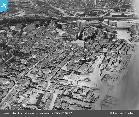
EPW016737 ENGLAND (1926). The town centre, Macclesfield, 1926. This image has been produced from a damaged copy-negative.
© Hawlfraint cyfranwyr OpenStreetMap a thrwyddedwyd gan yr OpenStreetMap Foundation. 2026. Trwyddedir y gartograffeg fel CC BY-SA.
Delweddau cyfagos (10)
EPW016737

EPW054378

EPW057639

EPW054375

EPW057375

EPW054380

EPW057374

EPW054374

EPW054379

EPW050709
, the Marlborough Mill and the John Clayton Ltd Timber Yard, Macclesfield, 1936. This image has been affected by flare.")
Manylion
| Pennawd | [EPW016737] The town centre, Macclesfield, 1926. This image has been produced from a damaged copy-negative. |
| Cyfeirnod | EPW016737 |
| Dyddiad | 28-August-1926 |
| Dolen | |
| Enw lle | MACCLESFIELD |
| Plwyf | |
| Ardal | |
| Gwlad | ENGLAND |
| Dwyreiniad / Gogleddiad | 391668, 373709 |
| Hydred / Lledred | -2.1249175028091, 53.260039775535 |
| Cyfeirnod Grid Cenedlaethol | SJ917737 |
Pinnau

jonnyhud |
Tuesday 22nd of December 2015 01:27:45 PM | |
|
jonnyhud |
Tuesday 22nd of December 2015 01:26:57 PM | |
|
jonnyhud |
Tuesday 22nd of December 2015 01:25:44 PM | |
|
jonnyhud |
Tuesday 22nd of December 2015 01:24:45 PM | |
|
jonnyhud |
Tuesday 22nd of December 2015 01:23:18 PM | |
|
jonnyhud |
Tuesday 22nd of December 2015 01:21:57 PM | |
|
jonnyhud |
Tuesday 22nd of December 2015 01:20:23 PM | |
|
jonnyhud |
Tuesday 22nd of December 2015 01:18:54 PM | |
|
jonnyhud |
Tuesday 22nd of December 2015 01:17:16 PM | |
|
jonnyhud |
Tuesday 22nd of December 2015 01:16:36 PM | |
|
jonnyhud |
Tuesday 22nd of December 2015 01:15:51 PM | |
|
jonnyhud |
Tuesday 22nd of December 2015 01:14:09 PM | |
|
jonnyhud |
Tuesday 22nd of December 2015 01:12:45 PM | |
|
jonnyhud |
Tuesday 22nd of December 2015 01:11:10 PM |