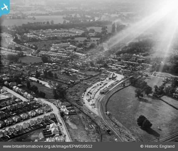
EPW016512 ENGLAND (1926). The railway station and environs, Edgware, 1926
© Hawlfraint cyfranwyr OpenStreetMap a thrwyddedwyd gan yr OpenStreetMap Foundation. 2026. Trwyddedir y gartograffeg fel CC BY-SA.
Delweddau cyfagos (18)
Manylion
| Pennawd | [EPW016512] The railway station and environs, Edgware, 1926 |
| Cyfeirnod | EPW016512 |
| Dyddiad | 25-August-1926 |
| Dolen | |
| Enw lle | EDGWARE |
| Plwyf | |
| Ardal | |
| Gwlad | ENGLAND |
| Dwyreiniad / Gogleddiad | 519330, 191655 |
| Hydred / Lledred | -0.27646428033869, 51.61059344299 |
| Cyfeirnod Grid Cenedlaethol | TQ193917 |
Pinnau

Drdub |
Sunday 13th of June 2021 05:03:59 PM | |

johno |
Wednesday 10th of March 2021 11:06:20 PM | |

johno |
Tuesday 16th of February 2021 06:52:31 PM | |

NthLondonBoy |
Tuesday 24th of March 2015 05:03:19 PM | |

French47 |
Saturday 28th of June 2014 05:41:36 PM | |

snapper31 |
Tuesday 21st of May 2013 04:23:42 PM | |

snapper31 |
Monday 7th of January 2013 03:06:04 PM | |

MB |
Thursday 6th of September 2012 10:58:51 PM | |

MB |
Thursday 6th of September 2012 10:55:11 PM | |

MB |
Thursday 6th of September 2012 10:54:39 PM | |

MB |
Thursday 6th of September 2012 10:54:02 PM |
Cyfraniadau Grŵp
A very rare picture of the original Edgware Station and Goods Yard. This line was part of the LNER route which extended to Mill Hill East, via an intermediate station at The Hale. It passed under the LMS main line at what would now be Mill Hill Broadway station. The bridge is still there by Lyndhurst Gardens but was completly bricked up when they built the M1. This line would have become part of the abandoned Northern Heights extension through to Bushey. |

gazzavc |
Tuesday 26th of June 2012 04:25:48 AM |


![[EPW016512] The railway station and environs, Edgware, 1926](http://britainfromabove.org.uk/sites/all/libraries/aerofilms-images/public/100x100/EPW/016/EPW016512.jpg)
![[EAW020692] Central Edgware and Hendon, Edgware, from the south-west, 1948](http://britainfromabove.org.uk/sites/all/libraries/aerofilms-images/public/100x100/EAW/020/EAW020692.jpg)
![[EPW005277] Wright and Sons Tool Works at Thorn Bank, Edgware, 1921](http://britainfromabove.org.uk/sites/all/libraries/aerofilms-images/public/100x100/EPW/005/EPW005277.jpg)
![[EAW020693] Edgware and the view towards Borehamwood, Edgware, from the south, 1948](http://britainfromabove.org.uk/sites/all/libraries/aerofilms-images/public/100x100/EAW/020/EAW020693.jpg)
![[EPW005281] Wright and Sons Tool Works at Thorn Bank, Edgware, 1921](http://britainfromabove.org.uk/sites/all/libraries/aerofilms-images/public/100x100/EPW/005/EPW005281.jpg)
![[EPW015982] Edgware Railway Station, Edgware, 1926. This image has been produced from a copy-negative.](http://britainfromabove.org.uk/sites/all/libraries/aerofilms-images/public/100x100/EPW/015/EPW015982.jpg)
![[EPW005282] Wright and Sons Tool Works at Thorn Bank, Edgware, 1921](http://britainfromabove.org.uk/sites/all/libraries/aerofilms-images/public/100x100/EPW/005/EPW005282.jpg)
![[EPW034622] Housing development to the north of the old village, Edgware, from the south, 1930](http://britainfromabove.org.uk/sites/all/libraries/aerofilms-images/public/100x100/EPW/034/EPW034622.jpg)
![[EPW031556] Edgware Railway Station and surroundings, Edgware, from the north-west, 1930](http://britainfromabove.org.uk/sites/all/libraries/aerofilms-images/public/100x100/EPW/031/EPW031556.jpg)
![[EPW034621] Housing development to the north of the old village, Edgware, from the south, 1930](http://britainfromabove.org.uk/sites/all/libraries/aerofilms-images/public/100x100/EPW/034/EPW034621.jpg)
![[EAW020695] Central Edgware, Edgware, 1948](http://britainfromabove.org.uk/sites/all/libraries/aerofilms-images/public/100x100/EAW/020/EAW020695.jpg)
![[EPW015987] The High Street, Edgware, 1926](http://britainfromabove.org.uk/sites/all/libraries/aerofilms-images/public/100x100/EPW/015/EPW015987.jpg)
![[EPW034546] The area around the High Street and railway station, Edgware, from the south-east, 1930](http://britainfromabove.org.uk/sites/all/libraries/aerofilms-images/public/100x100/EPW/034/EPW034546.jpg)
![[EPW009603] Station Road and environs, Edgware, 1923](http://britainfromabove.org.uk/sites/all/libraries/aerofilms-images/public/100x100/EPW/009/EPW009603.jpg)
![[EPW016516] The underground station, bus depot and environs, Edgware, 1926](http://britainfromabove.org.uk/sites/all/libraries/aerofilms-images/public/100x100/EPW/016/EPW016516.jpg)
![[EPW034554] The railway and underground stations and environs, Edgware, from the south-east, 1930](http://britainfromabove.org.uk/sites/all/libraries/aerofilms-images/public/100x100/EPW/034/EPW034554.jpg)
![[EPW009341] Construction of the underground station, Edgware, 1923](http://britainfromabove.org.uk/sites/all/libraries/aerofilms-images/public/100x100/EPW/009/EPW009341.jpg)
![[EPW031551] Edgware London Electric Railway Station and surroundings, Edgware, from the south-west, 1930](http://britainfromabove.org.uk/sites/all/libraries/aerofilms-images/public/100x100/EPW/031/EPW031551.jpg)