
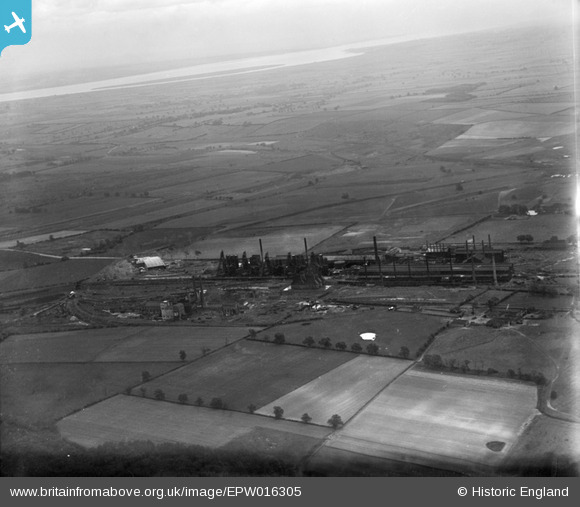
EPW016305 ENGLAND (1926). The Frodingham Iron Works, Scunthorpe, from the south-west, 1926
© Hawlfraint cyfranwyr OpenStreetMap a thrwyddedwyd gan yr OpenStreetMap Foundation. 2026. Trwyddedir y gartograffeg fel CC BY-SA.
Delweddau cyfagos (10)
EPW016305

EAW009632

EAW009409

EPW048532

EAW009638

EAW038762

EAW038761

EAW034812

EPW048943

EAW049665

Manylion
| Pennawd | [EPW016305] The Frodingham Iron Works, Scunthorpe, from the south-west, 1926 |
| Cyfeirnod | EPW016305 |
| Dyddiad | 14-July-1926 |
| Dolen | |
| Enw lle | SCUNTHORPE |
| Plwyf | |
| Ardal | |
| Gwlad | ENGLAND |
| Dwyreiniad / Gogleddiad | 488505, 413646 |
| Hydred / Lledred | -0.66205535869488, 53.611642453076 |
| Cyfeirnod Grid Cenedlaethol | SE885136 |
Pinnau

DaveH |
Monday 6th of January 2020 04:44:18 PM | |
|
DaveH |
Monday 6th of January 2020 04:43:09 PM | |
|
DaveH |
Monday 6th of January 2020 04:41:07 PM | |
|
DaveH |
Monday 6th of January 2020 04:39:13 PM | |
|
DaveH |
Monday 6th of January 2020 04:38:13 PM | |
|
DaveH |
Monday 6th of January 2020 04:34:39 PM | |
|
DaveH |
Monday 6th of January 2020 04:33:49 PM | |
|
DaveH |
Monday 6th of January 2020 04:30:41 PM | |
|
DaveH |
Monday 6th of January 2020 04:30:12 PM |
Cyfraniadau Grŵp
Looks like John Lysaghts, Normanby Park Steelworks to me, the river Humber and Read's Island near South Ferriby at top. Site now subject to reclamation. |
flyover |
Tuesday 22nd of January 2013 09:40:41 PM |