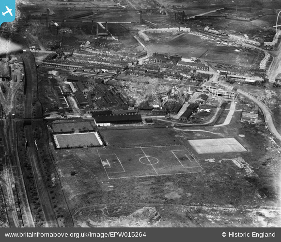
EPW015264 ENGLAND (1926). The Chillington Tool Works, Wolverhampton, 1926
© Hawlfraint cyfranwyr OpenStreetMap a thrwyddedwyd gan yr OpenStreetMap Foundation. 2026. Trwyddedir y gartograffeg fel CC BY-SA.
Manylion
| Pennawd | [EPW015264] The Chillington Tool Works, Wolverhampton, 1926 |
| Cyfeirnod | EPW015264 |
| Dyddiad | April-1926 |
| Dolen | |
| Enw lle | WOLVERHAMPTON |
| Plwyf | |
| Ardal | |
| Gwlad | ENGLAND |
| Dwyreiniad / Gogleddiad | 392903, 298149 |
| Hydred / Lledred | -2.1047495153435, 52.580748915164 |
| Cyfeirnod Grid Cenedlaethol | SO929981 |
Pinnau

DebbieA |
Sunday 26th of January 2020 07:01:35 PM | |

DebbieA |
Sunday 26th of January 2020 07:00:14 PM | |

alan alcock |
Tuesday 28th of February 2017 05:23:47 PM | |

alan alcock |
Tuesday 28th of February 2017 05:22:20 PM | |

alan alcock |
Tuesday 28th of February 2017 05:20:21 PM | |

alan alcock |
Tuesday 28th of February 2017 05:19:39 PM | |

alan alcock |
Tuesday 28th of February 2017 05:18:39 PM | |

alan alcock |
Tuesday 28th of February 2017 05:17:57 PM | |

alan alcock |
Tuesday 28th of February 2017 05:17:06 PM | |

alan alcock |
Tuesday 28th of February 2017 05:16:17 PM | |

alan alcock |
Tuesday 28th of February 2017 05:15:11 PM |


![[EPW015264] The Chillington Tool Works, Wolverhampton, 1926](http://britainfromabove.org.uk/sites/all/libraries/aerofilms-images/public/100x100/EPW/015/EPW015264.jpg)
![[EPW015266] The Chillington Tool Works, Wolverhampton, 1926](http://britainfromabove.org.uk/sites/all/libraries/aerofilms-images/public/100x100/EPW/015/EPW015266.jpg)
![[EPW015265] The Chillington Tool Works, Wolverhampton, 1926](http://britainfromabove.org.uk/sites/all/libraries/aerofilms-images/public/100x100/EPW/015/EPW015265.jpg)