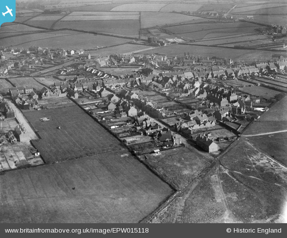
EPW015118 ENGLAND (1926). The village and environs, Chasetown, from the west, 1926
© Hawlfraint cyfranwyr OpenStreetMap a thrwyddedwyd gan yr OpenStreetMap Foundation. 2026. Trwyddedir y gartograffeg fel CC BY-SA.
Delweddau cyfagos (7)
Manylion
| Pennawd | [EPW015118] The village and environs, Chasetown, from the west, 1926 |
| Cyfeirnod | EPW015118 |
| Dyddiad | 12-April-1926 |
| Dolen | |
| Enw lle | CHASETOWN |
| Plwyf | BURNTWOOD |
| Ardal | |
| Gwlad | ENGLAND |
| Dwyreiniad / Gogleddiad | 404331, 308431 |
| Hydred / Lledred | -1.9359409095902, 52.673221169875 |
| Cyfeirnod Grid Cenedlaethol | SK043084 |
Pinnau

areed |
Monday 4th of January 2021 04:18:32 PM | |

areed |
Monday 4th of January 2021 04:14:54 PM | |

areed |
Thursday 23rd of April 2020 09:06:37 PM | |

areed |
Thursday 23rd of April 2020 09:05:09 PM | |

areed |
Thursday 23rd of April 2020 09:04:11 PM | |

areed |
Thursday 23rd of April 2020 09:03:52 PM | |

areed |
Thursday 23rd of April 2020 09:02:31 PM | |

areed |
Thursday 23rd of April 2020 09:02:14 PM |


![[EPW015118] The village and environs, Chasetown, from the west, 1926](http://britainfromabove.org.uk/sites/all/libraries/aerofilms-images/public/100x100/EPW/015/EPW015118.jpg)
![[EAW024535] The site of the Cannock Chase Collieries, Chasetown, 1949](http://britainfromabove.org.uk/sites/all/libraries/aerofilms-images/public/100x100/EAW/024/EAW024535.jpg)
![[EAW024541] Scrap processing on the site of Cannock Chase Collieries, Chasetown, from the south-west, 1949. This image has been produced from a print.](http://britainfromabove.org.uk/sites/all/libraries/aerofilms-images/public/100x100/EAW/024/EAW024541.jpg)
![[EAW024533] The site of the Cannock Chase Collieries, Chasetown, 1949](http://britainfromabove.org.uk/sites/all/libraries/aerofilms-images/public/100x100/EAW/024/EAW024533.jpg)
![[EPW015117] The High Street, Chasetown, 1926](http://britainfromabove.org.uk/sites/all/libraries/aerofilms-images/public/100x100/EPW/015/EPW015117.jpg)
![[EAW024532] The site of the Cannock Chase Collieries, Chasetown, 1949](http://britainfromabove.org.uk/sites/all/libraries/aerofilms-images/public/100x100/EAW/024/EAW024532.jpg)
![[EAW024540] The site of the Cannock Chase Collieries, Chasetown, 1949. This image has been produced from a damaged negative.](http://britainfromabove.org.uk/sites/all/libraries/aerofilms-images/public/100x100/EAW/024/EAW024540.jpg)