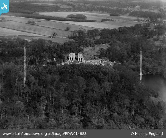
EPW014883 ENGLAND (1926). The ruins of Roche Abbey, Roche Abbey, 1926
© Hawlfraint cyfranwyr OpenStreetMap a thrwyddedwyd gan yr OpenStreetMap Foundation. 2026. Trwyddedir y gartograffeg fel CC BY-SA.
Delweddau cyfagos (7)
Manylion
| Pennawd | [EPW014883] The ruins of Roche Abbey, Roche Abbey, 1926 |
| Cyfeirnod | EPW014883 |
| Dyddiad | 29-May-1926 |
| Dolen | |
| Enw lle | ROCHE ABBEY |
| Plwyf | MALTBY |
| Ardal | |
| Gwlad | ENGLAND |
| Dwyreiniad / Gogleddiad | 454369, 389805 |
| Hydred / Lledred | -1.1821543230933, 53.402003050113 |
| Cyfeirnod Grid Cenedlaethol | SK544898 |
Pinnau

Maurice |
Friday 25th of January 2013 07:05:34 AM |
Cyfraniadau Grŵp
View looking east. Beautifully set in a valley landscaped by ‘Capability’ Brown in the 18th Century. Roche Abbey has one of the most complete ground plans of any English Cistercian monastery, laid out as excavated foundations. |

Class31 |
Wednesday 23rd of January 2013 10:18:46 PM |


![[EPW014883] The ruins of Roche Abbey, Roche Abbey, 1926](http://britainfromabove.org.uk/sites/all/libraries/aerofilms-images/public/100x100/EPW/014/EPW014883.jpg)
![[EAW003573] The abbey ruins, Roche Abbey, 1947](http://britainfromabove.org.uk/sites/all/libraries/aerofilms-images/public/100x100/EAW/003/EAW003573.jpg)
![[EPW014882] The ruins of Roche Abbey, Maltby, 1926. This image has been produced from a copy-negative.](http://britainfromabove.org.uk/sites/all/libraries/aerofilms-images/public/100x100/EPW/014/EPW014882.jpg)
![[EPW014885] The ruins of Roche Abbey, Maltby, 1926. This image has been produced from a copy-negative.](http://britainfromabove.org.uk/sites/all/libraries/aerofilms-images/public/100x100/EPW/014/EPW014885.jpg)
![[EPW014884] The ruins of Roche Abbey, Roche Abbey, 1926](http://britainfromabove.org.uk/sites/all/libraries/aerofilms-images/public/100x100/EPW/014/EPW014884.jpg)
![[EAW003574] The abbey ruins, Roche Abbey, 1947](http://britainfromabove.org.uk/sites/all/libraries/aerofilms-images/public/100x100/EAW/003/EAW003574.jpg)
![[EAW003575] The abbey ruins, Roche Abbey, 1947](http://britainfromabove.org.uk/sites/all/libraries/aerofilms-images/public/100x100/EAW/003/EAW003575.jpg)