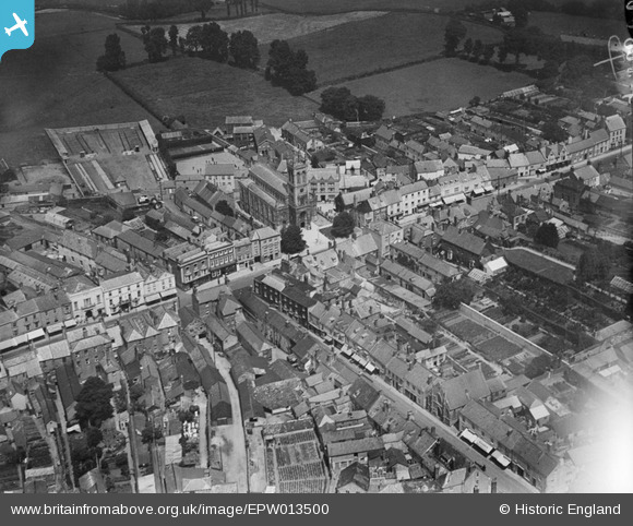
EPW013500 ENGLAND (1925). St Paul's Church and the High Street, Honiton, 1925
© Hawlfraint cyfranwyr OpenStreetMap a thrwyddedwyd gan yr OpenStreetMap Foundation. 2026. Trwyddedir y gartograffeg fel CC BY-SA.
Delweddau cyfagos (7)
Manylion
| Pennawd | [EPW013500] St Paul's Church and the High Street, Honiton, 1925 |
| Cyfeirnod | EPW013500 |
| Dyddiad | June-1925 |
| Dolen | |
| Enw lle | HONITON |
| Plwyf | HONITON |
| Ardal | |
| Gwlad | ENGLAND |
| Dwyreiniad / Gogleddiad | 316336, 100713 |
| Hydred / Lledred | -3.1873293036602, 50.799366772056 |
| Cyfeirnod Grid Cenedlaethol | ST163007 |


![[EPW013500] St Paul's Church and the High Street, Honiton, 1925](http://britainfromabove.org.uk/sites/all/libraries/aerofilms-images/public/100x100/EPW/013/EPW013500.jpg)
![[EPW023225] St Paul's Church and High Street, Honiton, 1928](http://britainfromabove.org.uk/sites/all/libraries/aerofilms-images/public/100x100/EPW/023/EPW023225.jpg)
![[EPW023224] St Paul's Church, Honiton, 1928](http://britainfromabove.org.uk/sites/all/libraries/aerofilms-images/public/100x100/EPW/023/EPW023224.jpg)
![[EAW051931] The town, Honiton, 1953. This image was marked by Aerofilms Ltd for photo editing.](http://britainfromabove.org.uk/sites/all/libraries/aerofilms-images/public/100x100/EAW/051/EAW051931.jpg)
![[EPW013499] The High Street, Honiton, 1925. This image has been produced from a copy-negative.](http://britainfromabove.org.uk/sites/all/libraries/aerofilms-images/public/100x100/EPW/013/EPW013499.jpg)
![[EAW051933] The town, Honiton, 1953](http://britainfromabove.org.uk/sites/all/libraries/aerofilms-images/public/100x100/EAW/051/EAW051933.jpg)
![[EAW051932] The town, Honiton, 1953. This image was marked by Aerofilms Ltd for photo editing.](http://britainfromabove.org.uk/sites/all/libraries/aerofilms-images/public/100x100/EAW/051/EAW051932.jpg)
