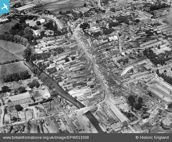
EPW013338 ENGLAND (1925). The town centre, Ware, 1925. This image has been produced from a copy-negative.
    © Hawlfraint cyfranwyr OpenStreetMap a thrwyddedwyd gan yr OpenStreetMap Foundation. 2025. Trwyddedir y gartograffeg fel CC BY-SA.
  
Delweddau cyfagos (17)
Manylion
| Pennawd | [EPW013338] The town centre, Ware, 1925. This image has been produced from a copy-negative. | 
| Cyfeirnod | EPW013338 | 
| Dyddiad | July-1925 | 
| Dolen | |
| Enw lle | WARE | 
| Plwyf | WARE | 
| Ardal | |
| Gwlad | ENGLAND | 
| Dwyreiniad / Gogleddiad | 535821, 214277 | 
| Hydred / Lledred | -0.029602253218425, 51.810157667467 | 
| Cyfeirnod Grid Cenedlaethol | TL358143 | 
Pinnau
Byddwch y cyntaf i ychwanegu sylw at y ddelwedd hon!
 
             
  ![[EPW013338] The town centre, Ware, 1925. This image has been produced from a copy-negative.](http://britainfromabove.org.uk/sites/all/libraries/aerofilms-images/public/100x100/EPW/013/EPW013338.jpg) 
  
                                          ![[EAW022367] Timber Yard off the River Lea and the town, Ware, 1949](http://britainfromabove.org.uk/sites/all/libraries/aerofilms-images/public/100x100/EAW/022/EAW022367.jpg) 
 ![[EPW025932] Christ Church and New Road, Ware, 1929](http://britainfromabove.org.uk/sites/all/libraries/aerofilms-images/public/100x100/EPW/025/EPW025932.jpg) 
 ![[EAW022366] The town, Ware, from the south-east, 1949](http://britainfromabove.org.uk/sites/all/libraries/aerofilms-images/public/100x100/EAW/022/EAW022366.jpg) 
 ![[EPW025936] Malthouse at Amwell End, Ware, 1929](http://britainfromabove.org.uk/sites/all/libraries/aerofilms-images/public/100x100/EPW/025/EPW025936.jpg) 
 ![[EPW025935] St Mary's Church and environs, Ware, 1929](http://britainfromabove.org.uk/sites/all/libraries/aerofilms-images/public/100x100/EPW/025/EPW025935.jpg) 
 ![[EPW025934] Christ Church and environs, Ware, 1929](http://britainfromabove.org.uk/sites/all/libraries/aerofilms-images/public/100x100/EPW/025/EPW025934.jpg) 
 ![[EAW022404] The J. Gliksten and Son Ltd timber yard next to the River Lea and environs, Ware, 1949](http://britainfromabove.org.uk/sites/all/libraries/aerofilms-images/public/100x100/EAW/022/EAW022404.jpg) 
 ![[EAW022403] The J. Gliksten and Son Ltd timber yard next to the River Lea and environs, Ware, 1949. This image was marked by Aerofilms Ltd for photo editing.](http://britainfromabove.org.uk/sites/all/libraries/aerofilms-images/public/100x100/EAW/022/EAW022403.jpg) 
 ![[EAW022365] The town, Ware, from the south-east, 1949](http://britainfromabove.org.uk/sites/all/libraries/aerofilms-images/public/100x100/EAW/022/EAW022365.jpg) 
 ![[EPW025931] St Mary's Church and environs, Ware, 1929](http://britainfromabove.org.uk/sites/all/libraries/aerofilms-images/public/100x100/EPW/025/EPW025931.jpg) 
 ![[EAW022401] The J. Gliksten and Son Ltd timber yard next to the River Lea and environs, Ware, from the south-east, 1949](http://britainfromabove.org.uk/sites/all/libraries/aerofilms-images/public/100x100/EAW/022/EAW022401.jpg) 
 ![[EAW022399] The J. Gliksten and Son Ltd timber yard next to the River Lea, Ware, 1949. This image was marked by Aerofilms Ltd for photo editing.](http://britainfromabove.org.uk/sites/all/libraries/aerofilms-images/public/100x100/EAW/022/EAW022399.jpg) 
 ![[EAW022400] The J. Gliksten and Son Ltd timber yard next to the River Lea, Ware, 1949](http://britainfromabove.org.uk/sites/all/libraries/aerofilms-images/public/100x100/EAW/022/EAW022400.jpg) 
 ![[EPW025928] Works and wharfage on the River Lee, Ware, 1929](http://britainfromabove.org.uk/sites/all/libraries/aerofilms-images/public/100x100/EPW/025/EPW025928.jpg) 
 ![[EPW013340] Malthouse beside The Cut near Ware Bridge, Ware, 1925](http://britainfromabove.org.uk/sites/all/libraries/aerofilms-images/public/100x100/EPW/013/EPW013340.jpg) 
 ![[EPW025929] Baldock Street and environs, Ware, 1929](http://britainfromabove.org.uk/sites/all/libraries/aerofilms-images/public/100x100/EPW/025/EPW025929.jpg)