
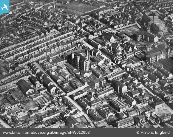
EPW012653 ENGLAND (1925). The New Basford National Ordnance Factory off High Church Street, New Basford, 1925. This image has been produced from a copy-negative.
© Hawlfraint cyfranwyr OpenStreetMap a thrwyddedwyd gan yr OpenStreetMap Foundation. 2026. Trwyddedir y gartograffeg fel CC BY-SA.
Delweddau cyfagos (2)
EPW012653

EPW012652

Manylion
| Pennawd | [EPW012653] The New Basford National Ordnance Factory off High Church Street, New Basford, 1925. This image has been produced from a copy-negative. |
| Cyfeirnod | EPW012653 |
| Dyddiad | April-1925 |
| Dolen | |
| Enw lle | NEW BASFORD |
| Plwyf | |
| Ardal | |
| Gwlad | ENGLAND |
| Dwyreiniad / Gogleddiad | 455971, 342122 |
| Hydred / Lledred | -1.1664132655467, 52.973214442248 |
| Cyfeirnod Grid Cenedlaethol | SK560421 |
Pinnau

bantam |
Thursday 22nd of September 2016 12:40:52 PM | |
|
bantam |
Thursday 22nd of September 2016 12:39:10 PM | |
|
bantam |
Thursday 22nd of September 2016 12:37:34 PM | |
|
bantam |
Thursday 22nd of September 2016 12:36:28 PM | |
|
bantam |
Thursday 22nd of September 2016 12:35:25 PM | |
|
bantam |
Thursday 22nd of September 2016 12:34:36 PM | |
|
bantam |
Thursday 22nd of September 2016 12:33:17 PM |
Cyfraniadau Grŵp

NOF New Basford opened Feb 1918 (see resources) I don't know the area so cannot add a pin, was looking at the area for family history when I noticed the image. |

spugs |
Sunday 24th of May 2015 01:47:09 PM |