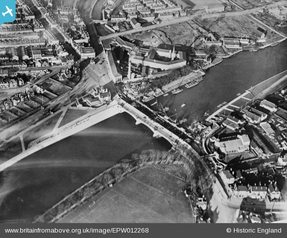
EPW012268 ENGLAND (1924). The widening of Trent Bridge in progress, Nottingham, 1924. This image has been produced from a copy-negative.
© Hawlfraint cyfranwyr OpenStreetMap a thrwyddedwyd gan yr OpenStreetMap Foundation. 2026. Trwyddedir y gartograffeg fel CC BY-SA.
Delweddau cyfagos (14)
Manylion
| Pennawd | [EPW012268] The widening of Trent Bridge in progress, Nottingham, 1924. This image has been produced from a copy-negative. |
| Cyfeirnod | EPW012268 |
| Dyddiad | November-1924 |
| Dolen | |
| Enw lle | NOTTINGHAM |
| Plwyf | |
| Ardal | |
| Gwlad | ENGLAND |
| Dwyreiniad / Gogleddiad | 458124, 338254 |
| Hydred / Lledred | -1.1350462412887, 52.938214852358 |
| Cyfeirnod Grid Cenedlaethol | SK581383 |
Pinnau

KC |
Sunday 1st of December 2024 06:27:37 PM |


![[EPW012268] The widening of Trent Bridge in progress, Nottingham, 1924. This image has been produced from a copy-negative.](http://britainfromabove.org.uk/sites/all/libraries/aerofilms-images/public/100x100/EPW/012/EPW012268.jpg)
![[EPW038630] Trent Bridge, Forest Football Ground and Trent Bridge Cricket Ground, Nottingham, 1932](http://britainfromabove.org.uk/sites/all/libraries/aerofilms-images/public/100x100/EPW/038/EPW038630.jpg)
![[EPW012648] Trent Bridge, Nottingham, 1925. This image has been produced from a print.](http://britainfromabove.org.uk/sites/all/libraries/aerofilms-images/public/100x100/EPW/012/EPW012648.jpg)
![[EPW021125] Trent Bridge, West Bridgford, 1928](http://britainfromabove.org.uk/sites/all/libraries/aerofilms-images/public/100x100/EPW/021/EPW021125.jpg)
![[EPW021126] Trent Bridge and the Palace Theatre, West Bridgford, 1928](http://britainfromabove.org.uk/sites/all/libraries/aerofilms-images/public/100x100/EPW/021/EPW021126.jpg)
![[EPW041576] Trent Bridge and the Turney Bros Ltd Leather Works, Nottingham, 1933](http://britainfromabove.org.uk/sites/all/libraries/aerofilms-images/public/100x100/EPW/041/EPW041576.jpg)
![[EPW041575] Trent Bridge and the Turney Bros Ltd Leather Works, Nottingham, 1933](http://britainfromabove.org.uk/sites/all/libraries/aerofilms-images/public/100x100/EPW/041/EPW041575.jpg)
![[EPW041574] Trent Bridge, the Turney Bros Ltd Leather Works and the County Football Ground, Nottingham, 1933](http://britainfromabove.org.uk/sites/all/libraries/aerofilms-images/public/100x100/EPW/041/EPW041574.jpg)
![[EAW025936] Sports Grounds surrounding Trent Bridge and County Hall, West Bridgford, 1949](http://britainfromabove.org.uk/sites/all/libraries/aerofilms-images/public/100x100/EAW/025/EAW025936.jpg)
![[EPW041578] The Forest Football Ground and the Turney Bros Ltd Leather Works alongside the River Trent, Nottingham, 1933](http://britainfromabove.org.uk/sites/all/libraries/aerofilms-images/public/100x100/EPW/041/EPW041578.jpg)
![[EPW041579] The Turney Bros Ltd Leather Works, Nottingham, 1933](http://britainfromabove.org.uk/sites/all/libraries/aerofilms-images/public/100x100/EPW/041/EPW041579.jpg)
![[EPW041577] The Forest Football Ground and the Turney Bros Ltd Leather Works alongside the River Trent, Nottingham, 1933](http://britainfromabove.org.uk/sites/all/libraries/aerofilms-images/public/100x100/EPW/041/EPW041577.jpg)
![[EPR000153] Trent Bridge Cricket Ground and envions, West Bridgford, 1934](http://britainfromabove.org.uk/sites/all/libraries/aerofilms-images/public/100x100/EPR/000/EPR000153.jpg)
![[EPW038631] Victoria Embankment and the Memorial Gardens, Nottingham, 1932](http://britainfromabove.org.uk/sites/all/libraries/aerofilms-images/public/100x100/EPW/038/EPW038631.jpg)