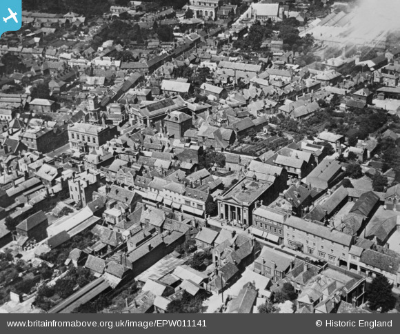
EPW011141 ENGLAND (1924). London Street and the town centre, Basingstoke, 1924. This image has been produced from a copy-negative.
    © Hawlfraint cyfranwyr OpenStreetMap a thrwyddedwyd gan yr OpenStreetMap Foundation. 2025. Trwyddedir y gartograffeg fel CC BY-SA.
  
Delweddau cyfagos (8)
Manylion
| Pennawd | [EPW011141] London Street and the town centre, Basingstoke, 1924. This image has been produced from a copy-negative. | 
| Cyfeirnod | EPW011141 | 
| Dyddiad | July-1924 | 
| Dolen | |
| Enw lle | BASINGSTOKE | 
| Plwyf | |
| Ardal | |
| Gwlad | ENGLAND | 
| Dwyreiniad / Gogleddiad | 463852, 151922 | 
| Hydred / Lledred | -1.0847662828341, 51.26236527016 | 
| Cyfeirnod Grid Cenedlaethol | SU639519 | 
 
             
  ![[EPW011141] London Street and the town centre, Basingstoke, 1924. This image has been produced from a copy-negative.](http://britainfromabove.org.uk/sites/all/libraries/aerofilms-images/public/100x100/EPW/011/EPW011141.jpg) 
  
                                          ![[EPW022758] The Market Place, Basingstoke, 1928. This image has been produced from a print.](http://britainfromabove.org.uk/sites/all/libraries/aerofilms-images/public/100x100/EPW/022/EPW022758.jpg) 
 ![[EPW033383] The Market Place, London Street and the War Memorial Park, Basingstoke, 1930](http://britainfromabove.org.uk/sites/all/libraries/aerofilms-images/public/100x100/EPW/033/EPW033383.jpg) 
 ![[EPW022694] The Town Hall and Market Place, Basingstoke, 1928. This image has been produced from a copy-negative.](http://britainfromabove.org.uk/sites/all/libraries/aerofilms-images/public/100x100/EPW/022/EPW022694.jpg) 
 ![[EPW011142] The town centre, Basingstoke, 1924. This image has been produced from a print.](http://britainfromabove.org.uk/sites/all/libraries/aerofilms-images/public/100x100/EPW/011/EPW011142.jpg) 
 ![[EPW022760] The junction of New Street and Winchester Street, Basingstoke, 1928](http://britainfromabove.org.uk/sites/all/libraries/aerofilms-images/public/100x100/EPW/022/EPW022760.jpg) 
 ![[EPW022757] St Michael's Church, Basingstoke, 1928. This image has been produced from a print.](http://britainfromabove.org.uk/sites/all/libraries/aerofilms-images/public/100x100/EPW/022/EPW022757.jpg) 
 ![[EPW011139] Mortimer Lane and environs, Basingstoke, 1924. This image has been produced from a copy-negative.](http://britainfromabove.org.uk/sites/all/libraries/aerofilms-images/public/100x100/EPW/011/EPW011139.jpg) 
  Original town hall, up until the 1960s expansion of the town.
 Original town hall, up until the 1960s expansion of the town.