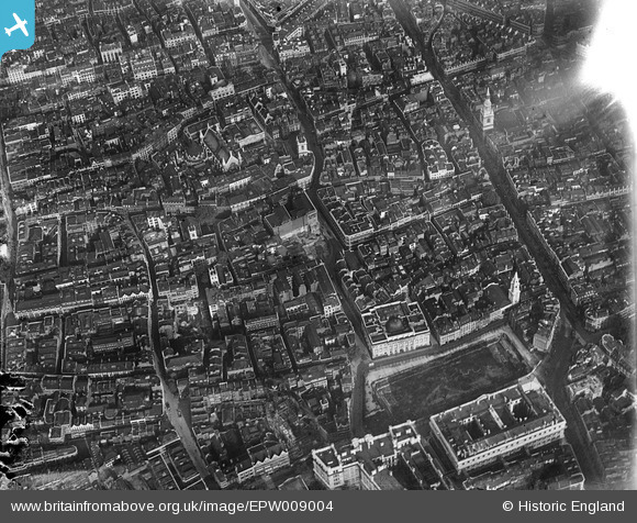
EPW009004 ENGLAND (1923). Gresham Street and environs, London, 1923
    © Hawlfraint cyfranwyr OpenStreetMap a thrwyddedwyd gan yr OpenStreetMap Foundation. 2025. Trwyddedir y gartograffeg fel CC BY-SA.
  
Delweddau cyfagos (48)
Manylion
| Pennawd | [EPW009004] Gresham Street and environs, London, 1923 | 
| Cyfeirnod | EPW009004 | 
| Dyddiad | July-1923 | 
| Dolen | |
| Enw lle | LONDON | 
| Plwyf | |
| Ardal | |
| Gwlad | ENGLAND | 
| Dwyreiniad / Gogleddiad | 532333, 181365 | 
| Hydred / Lledred | -0.09263747417033, 51.515206443122 | 
| Cyfeirnod Grid Cenedlaethol | TQ323814 | 
Pinnau
|  The church of Saint Alban. (Situated in Wood Street.) |   Hermann the German | Friday 25th of August 2017 05:40:36 PM | 
|  The empty site of 51-55 Gresham Street. |   Hermann the German | Friday 25th of August 2017 05:36:26 PM | 
|  Queen Victoria Street | Class31 | Friday 13th of June 2014 10:28:45 AM | 
|  Newgate Street | Class31 | Friday 13th of June 2014 10:28:19 AM | 
|  Gresham Street | Class31 | Friday 13th of June 2014 10:27:47 AM | 
|  Cheapside | Class31 | Friday 13th of June 2014 10:27:25 AM | 
|   Alan McFaden | Thursday 12th of September 2013 05:57:16 PM | |
|   Alan McFaden | Thursday 12th of September 2013 05:55:07 PM | |
|   Alan McFaden | Thursday 12th of September 2013 05:54:13 PM | |
|   Alan McFaden | Thursday 12th of September 2013 05:53:08 PM | |
|   Alan McFaden | Thursday 12th of September 2013 05:52:24 PM | |
|   Alan McFaden | Thursday 12th of September 2013 05:51:48 PM | |
|  St Stephen's Church, Coleman Street |   Chelsea61 | Sunday 4th of August 2013 12:11:51 AM | 
 
             
  ![[EPW009004] Gresham Street and environs, London, 1923](http://britainfromabove.org.uk/sites/all/libraries/aerofilms-images/public/100x100/EPW/009/EPW009004.jpg) 
  
                                          ![[EPW009001] Wood Street and environs, London, 1923](http://britainfromabove.org.uk/sites/all/libraries/aerofilms-images/public/100x100/EPW/009/EPW009001.jpg) 
 ![[EPW009002] St Paul's Cathedral, Wood Street and environs, London, 1923](http://britainfromabove.org.uk/sites/all/libraries/aerofilms-images/public/100x100/EPW/009/EPW009002.jpg) 
 ![[EPW009005] Wood Street and environs, London, 1923](http://britainfromabove.org.uk/sites/all/libraries/aerofilms-images/public/100x100/EPW/009/EPW009005.jpg) 
 ![[EPW009003] Wood Street and environs, London, 1923](http://britainfromabove.org.uk/sites/all/libraries/aerofilms-images/public/100x100/EPW/009/EPW009003.jpg) 
 ![[EPW009000] Wood Street and environs, London, 1923](http://britainfromabove.org.uk/sites/all/libraries/aerofilms-images/public/100x100/EPW/009/EPW009000.jpg) 
 ![[EAW011114] Cleared site by Goldsmiths' Hall following bomb damage and the area around Cheapside and Gresham Street, London, 1947](http://britainfromabove.org.uk/sites/all/libraries/aerofilms-images/public/100x100/EAW/011/EAW011114.jpg) 
 ![[EAW048555] A cityscape over St Paul's Cathedral, Finsbury Circus and the Tower of London, London, 1953](http://britainfromabove.org.uk/sites/all/libraries/aerofilms-images/public/100x100/EAW/048/EAW048555.jpg) 
 ![[EPW045433A] The Guildhall and environs, London, 1934. This image has been produced from a copy-negative.](http://britainfromabove.org.uk/sites/all/libraries/aerofilms-images/public/100x100/EPW/045/EPW045433A.jpg) 
 ![[EPW045433] The Guildhall and environs, London, 1934. This image has been produced from a copy-negative.](http://britainfromabove.org.uk/sites/all/libraries/aerofilms-images/public/100x100/EPW/045/EPW045433.jpg) 
 ![[EPW055311] Cheapside, Cannon Street and environs, London, from the south-east, 1937](http://britainfromabove.org.uk/sites/all/libraries/aerofilms-images/public/100x100/EPW/055/EPW055311.jpg) 
 ![[EAW011115] Cleared sites around Wood Street following bomb damage, London, 1947](http://britainfromabove.org.uk/sites/all/libraries/aerofilms-images/public/100x100/EAW/011/EAW011115.jpg) 
 ![[EPW045434] The Guildhall and environs, London, 1934](http://britainfromabove.org.uk/sites/all/libraries/aerofilms-images/public/100x100/EPW/045/EPW045434.jpg) 
 ![[EAW011191] Cleared sites around Wood Street and Jewin Crescent following bomb damage, London, 1947](http://britainfromabove.org.uk/sites/all/libraries/aerofilms-images/public/100x100/EAW/011/EAW011191.jpg) 
 ![[EAW000506] St Paul's Cathedral and surrounding bomb damage and clearance, London, 1946](http://britainfromabove.org.uk/sites/all/libraries/aerofilms-images/public/100x100/EAW/000/EAW000506.jpg) 
 ![[EAW000508] St Paul's Cathedral and surrounding bomb damage and clearance, London, 1946](http://britainfromabove.org.uk/sites/all/libraries/aerofilms-images/public/100x100/EAW/000/EAW000508.jpg) 
 ![[EPW028614] St Paul's Cathedral and environs, London, 1929](http://britainfromabove.org.uk/sites/all/libraries/aerofilms-images/public/100x100/EPW/028/EPW028614.jpg) 
 ![[EPW028612] St Paul's Cathedral and environs, London, 1929](http://britainfromabove.org.uk/sites/all/libraries/aerofilms-images/public/100x100/EPW/028/EPW028612.jpg) 
 ![[EAW026314] Finsbury Circus, Liverpool Street Station and the City of London, London, from the west, 1949](http://britainfromabove.org.uk/sites/all/libraries/aerofilms-images/public/100x100/EAW/026/EAW026314.jpg) 
 ![[EAW000509] Clearance around St Paul's Cathedral, Cheapside and environs, London, 1946](http://britainfromabove.org.uk/sites/all/libraries/aerofilms-images/public/100x100/EAW/000/EAW000509.jpg) 
 ![[EAW021730] A cityscape over central London, London, 1949. This image has been produced from a print.](http://britainfromabove.org.uk/sites/all/libraries/aerofilms-images/public/100x100/EAW/021/EAW021730.jpg) 
 ![[EAW020403] St Paul's Cathedral and environs, London, 1948](http://britainfromabove.org.uk/sites/all/libraries/aerofilms-images/public/100x100/EAW/020/EAW020403.jpg) 
 ![[EPW028615] St Paul's Cathedral and environs, London, 1929](http://britainfromabove.org.uk/sites/all/libraries/aerofilms-images/public/100x100/EPW/028/EPW028615.jpg) 
 ![[EAW018351] St Paul's Cathedral and surrounding bomb damaged area, London, 1948. This image has been produced from a print.](http://britainfromabove.org.uk/sites/all/libraries/aerofilms-images/public/100x100/EAW/018/EAW018351.jpg) 
 ![[EPW028034] A cityscape over St Paul's Cathedral, Queen Victoria Street and environs, London, 1929. This image has been produced from a print.](http://britainfromabove.org.uk/sites/all/libraries/aerofilms-images/public/100x100/EPW/028/EPW028034.jpg) 
 ![[EPW028616] St Paul's Cathedral and environs, London, 1929](http://britainfromabove.org.uk/sites/all/libraries/aerofilms-images/public/100x100/EPW/028/EPW028616.jpg) 
 ![[EAW053007] St Paul's Cathedral, surrounding cleared areas and environs, London, 1953](http://britainfromabove.org.uk/sites/all/libraries/aerofilms-images/public/100x100/EAW/053/EAW053007.jpg) 
 ![[EAW011370] Bomb damaged and cleared areas to the north-east of St Paul's Cathedral, London, 1947](http://britainfromabove.org.uk/sites/all/libraries/aerofilms-images/public/100x100/EAW/011/EAW011370.jpg) 
 ![[EPW028611] St Paul's Cathedral and environs, London, 1929](http://britainfromabove.org.uk/sites/all/libraries/aerofilms-images/public/100x100/EPW/028/EPW028611.jpg) 
 ![[EPW028613] St Paul's Cathedral and environs, London, 1929](http://britainfromabove.org.uk/sites/all/libraries/aerofilms-images/public/100x100/EPW/028/EPW028613.jpg) 
 ![[EPW055300] The area between St Martin's Le Grand and Bunhill Row, London, from the south, 1937](http://britainfromabove.org.uk/sites/all/libraries/aerofilms-images/public/100x100/EPW/055/EPW055300.jpg) 
 ![[EAW011369] Bomb damaged and cleared areas on the east side of Aldersgate Street, London, 1947](http://britainfromabove.org.uk/sites/all/libraries/aerofilms-images/public/100x100/EAW/011/EAW011369.jpg) 
 ![[EAW041956] St Paul's Cathedral and the city, London, 1952](http://britainfromabove.org.uk/sites/all/libraries/aerofilms-images/public/100x100/EAW/041/EAW041956.jpg) 
 ![[EAW011178] Cleared areas following bomb damage to the east of St Paul's Cathedral, London, 1947](http://britainfromabove.org.uk/sites/all/libraries/aerofilms-images/public/100x100/EAW/011/EAW011178.jpg) 
 ![[EPW062008] Aldersgate, London, 1939](http://britainfromabove.org.uk/sites/all/libraries/aerofilms-images/public/100x100/EPW/062/EPW062008.jpg) 
 ![[EPW062007] Aldersgate, London, 1939](http://britainfromabove.org.uk/sites/all/libraries/aerofilms-images/public/100x100/EPW/062/EPW062007.jpg) 
 ![[EAW053010] St Paul's Cathedral, surrounding cleared areas and environs, London, 1953](http://britainfromabove.org.uk/sites/all/libraries/aerofilms-images/public/100x100/EAW/053/EAW053010.jpg) 
 ![[EAW005233] The area around St Paul's Cathedral and the River Thames from Southwark Bridge to Tower Bridge and beyond, London, from the north-west, 1947](http://britainfromabove.org.uk/sites/all/libraries/aerofilms-images/public/100x100/EAW/005/EAW005233.jpg) 
 ![[EPW062011] Aldersgate Street, London, 1939](http://britainfromabove.org.uk/sites/all/libraries/aerofilms-images/public/100x100/EPW/062/EPW062011.jpg) 
 ![[EPW028032] A cityscape over St Paul's Cathedral, Queen Victoria Street and environs, London, 1929. This image has been produced from a print.](http://britainfromabove.org.uk/sites/all/libraries/aerofilms-images/public/100x100/EPW/028/EPW028032.jpg) 
 ![[EPW037976] St Paul's Cathedral and environs, London, 1932](http://britainfromabove.org.uk/sites/all/libraries/aerofilms-images/public/100x100/EPW/037/EPW037976.jpg) 
 ![[EPW062031] Aldersgate Street and environs, London, 1939](http://britainfromabove.org.uk/sites/all/libraries/aerofilms-images/public/100x100/EPW/062/EPW062031.jpg) 
 ![[EAW000660] St Paul's Cathedral and the surrounding bomb damaged area, London, 1946](http://britainfromabove.org.uk/sites/all/libraries/aerofilms-images/public/100x100/EAW/000/EAW000660.jpg) 
 ![[EAW011371] Bomb damaged and cleared areas to the east of St Paul's Cathedral, London, 1947](http://britainfromabove.org.uk/sites/all/libraries/aerofilms-images/public/100x100/EAW/011/EAW011371.jpg) 
 ![[EPW062010] St Bartholomew's Hospital and Aldersgate Street, London, 1939](http://britainfromabove.org.uk/sites/all/libraries/aerofilms-images/public/100x100/EPW/062/EPW062010.jpg) 
 ![[EAW049464] The bomb-damaged Cripplegate area (site of The Barbican Centre), London, 1953](http://britainfromabove.org.uk/sites/all/libraries/aerofilms-images/public/100x100/EAW/049/EAW049464.jpg) 
 ![[EPW055297] St Paul's Cathedral and environs, London, 1937](http://britainfromabove.org.uk/sites/all/libraries/aerofilms-images/public/100x100/EPW/055/EPW055297.jpg) 
 ![[EAW000534] St Paul's Cathedral and the bomb damaged and cleared area around Moorgate Street Station and environs, London, from the south, 1946](http://britainfromabove.org.uk/sites/all/libraries/aerofilms-images/public/100x100/EAW/000/EAW000534.jpg) 


