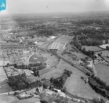
EPW006195 ENGLAND (1921). The London, Midland and Scottish Railway Carriage Shed beside the Croxley Green Curve, West Watford, from the south-west, 1921
© Hawlfraint cyfranwyr OpenStreetMap a thrwyddedwyd gan yr OpenStreetMap Foundation. 2026. Trwyddedir y gartograffeg fel CC BY-SA.
Manylion
| Pennawd | [EPW006195] The London, Midland and Scottish Railway Carriage Shed beside the Croxley Green Curve, West Watford, from the south-west, 1921 |
| Cyfeirnod | EPW006195 |
| Dyddiad | April-1921 |
| Dolen | |
| Enw lle | WEST WATFORD |
| Plwyf | |
| Ardal | |
| Gwlad | ENGLAND |
| Dwyreiniad / Gogleddiad | 510536, 195255 |
| Hydred / Lledred | -0.40228806559765, 51.644748786135 |
| Cyfeirnod Grid Cenedlaethol | TQ105953 |
Pinnau

Bluid |
Thursday 12th of November 2020 10:20:39 AM | |

Bluid |
Thursday 12th of November 2020 10:11:40 AM | |

OldBill |
Saturday 28th of December 2019 05:49:23 PM | |

Pdadme |
Saturday 23rd of November 2019 01:31:00 PM | |

Guy |
Sunday 21st of July 2019 06:23:31 PM | |

Guy |
Sunday 21st of July 2019 06:21:23 PM | |

Guy |
Sunday 21st of July 2019 06:20:03 PM | |

The Laird |
Thursday 6th of June 2019 09:24:01 AM | |

The Laird |
Wednesday 16th of September 2015 10:54:41 PM | |

The Laird |
Wednesday 16th of September 2015 10:34:19 PM | |

The Laird |
Wednesday 16th of September 2015 10:20:49 PM | |

The Laird |
Wednesday 29th of April 2015 08:45:39 PM | |

The Laird |
Wednesday 29th of April 2015 08:42:03 PM | |

HenryWRWhite |
Friday 10th of October 2014 12:41:02 PM | |

Bluid |
Monday 24th of March 2014 09:48:52 PM | |

Bluid |
Tuesday 25th of February 2014 06:08:42 PM | |

Bluid |
Tuesday 25th of February 2014 06:06:54 PM | |

Bluid |
Tuesday 25th of February 2014 06:04:32 PM | |

Bluid |
Tuesday 25th of February 2014 06:01:09 PM | |

Bluid |
Tuesday 25th of February 2014 05:59:12 PM | |

Bluid |
Sunday 7th of April 2013 09:02:44 AM | |

Bluid |
Saturday 6th of April 2013 08:45:51 PM | |

Bluid |
Saturday 6th of April 2013 08:43:26 PM | |

John Swain |
Thursday 26th of July 2012 09:47:02 AM | |
This not Hollywell Farm, which is out of shot, on the other side of the railway. Whatever this place used to be, it is now long gone, under Stripling Rd Playground. This is as close as I could get to it off Google maps: https://www.google.co.uk/maps/@51.6441927,-0.4103285,109a,35y,75.22h,79.07t/data=!3m1!1e3?hl=en&authuser=0 |

Pdadme |
Saturday 23rd of November 2019 01:24:57 PM |

John Swain |
Thursday 26th of July 2012 09:42:27 AM | |

John Swain |
Thursday 26th of July 2012 09:38:25 AM | |

John Swain |
Thursday 26th of July 2012 09:35:29 AM | |

John Swain |
Thursday 26th of July 2012 09:28:23 AM | |

John Swain |
Thursday 26th of July 2012 09:26:05 AM | |

Puffpuffbuff |
Thursday 28th of June 2012 05:19:28 PM | |

Puffpuffbuff |
Thursday 28th of June 2012 05:18:28 PM | |

Puffpuffbuff |
Thursday 28th of June 2012 05:17:34 PM | |

Puffpuffbuff |
Thursday 28th of June 2012 05:16:35 PM | |

Puffpuffbuff |
Thursday 28th of June 2012 05:15:38 PM | |
This impressive viaduct was built over the river Colne and The Dell (later Oxhey Park) in 1912, to carry the L&NWR Bushey Curve electric railway from Bushey Station and the Arches. |

John Swain |
Thursday 26th of July 2012 09:21:35 AM |

Puffpuffbuff |
Thursday 28th of June 2012 05:14:50 PM | |

Puffpuffbuff |
Thursday 28th of June 2012 05:13:47 PM | |

Puffpuffbuff |
Thursday 28th of June 2012 05:12:10 PM |
Cyfraniadau Grŵp
Benskins Brewery |

2hal4cor |
Thursday 22nd of January 2015 01:47:33 PM |
A superb shot of the L.M.S. 'Croxley' Car Sheds at West Watford. Just visible on one of the left hand tracks in the shed is the unmistakeable outline of an 'Oerlikan' Set with an early Underground 'Tube' set on a right hand track. Visible bottom left is the branch to West Watford and Croxley (L.M.S.) whilst at bottom right is the branch to Rickmansworth - Church Street. Immediately to the left of the sheds, the line curves away to go to Watford Junction via Watford High Street. The southern two tracks of the triangle are clearly shown being used for the storage of redundant wagons. Just above the triangle are the Western Bushey arches curving away to the right to join the E.C.M.L. at Bushey. Note also in the middle distance, a passenger train on the E.C.M.L. heading for Watford Junction. |

Puffpuffbuff |
Thursday 22nd of January 2015 01:45:49 PM |
Some fascinating detail here, although I'm puzzled by your regular reference to the ECML on this and other images in the Watford/Bushey series. Contemporary maps in my collection indicate this as being a London & North Western Railway main line until January 1st 1923, after which it is a London Midland & Scottish Railway until nationalisation in 1948. |

John Swain |
Thursday 26th of July 2012 09:01:39 AM |
Slip of the finger i hope you mean WCML |

2hal4cor |
Thursday 22nd of January 2015 01:45:49 PM |

John Swain |
Friday 9th of August 2013 10:15:27 AM | |

Bluid |
Sunday 7th of April 2013 09:00:30 AM | |

Puffpuffbuff |
Sunday 1st of July 2012 10:34:00 AM | |

Photo of "Croxley Depot" (now gone) found elsewhere on internet. |

Rustic Leni |
Saturday 30th of June 2012 08:37:52 PM |


