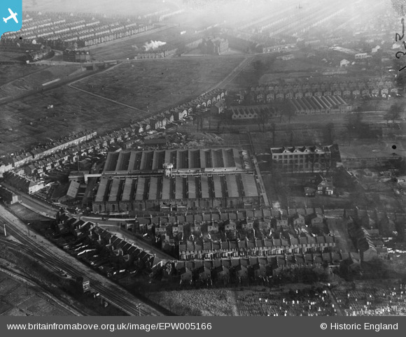
EPW005166 ENGLAND (1921). Electrical Engineering Works, Church End, 1921
© Hawlfraint cyfranwyr OpenStreetMap a thrwyddedwyd gan yr OpenStreetMap Foundation. 2026. Trwyddedir y gartograffeg fel CC BY-SA.
Delweddau cyfagos (15)
Manylion
| Pennawd | [EPW005166] Electrical Engineering Works, Church End, 1921 |
| Cyfeirnod | EPW005166 |
| Dyddiad | 12-January-1921 |
| Dolen | |
| Enw lle | CHURCH END |
| Plwyf | |
| Ardal | |
| Gwlad | ENGLAND |
| Dwyreiniad / Gogleddiad | 521563, 184978 |
| Hydred / Lledred | -0.24654011298105, 51.550101678155 |
| Cyfeirnod Grid Cenedlaethol | TQ216850 |
Pinnau

greenchief |
Tuesday 4th of March 2014 02:31:52 PM | |

greenchief |
Tuesday 4th of March 2014 02:25:01 PM | |
It would just have been the Metropolitan Railway and the adjacent Great Central Railway at this time. The Bakerloo did not reach this area until 1939. |

The Laird |
Tuesday 2nd of August 2016 03:58:45 PM |

greenchief |
Monday 5th of August 2013 10:05:31 AM | |

greenchief |
Monday 5th of August 2013 10:04:16 AM | |

Class31 |
Saturday 25th of August 2012 09:44:50 PM |
Cyfraniadau Grŵp
British Thompson & Houston - Switchgear Division works. These works housed the original 'network analyser' used to design the original National Grid of 132Kv |

greenchief |
Tuesday 4th of March 2014 02:30:59 PM |


![[EPW005166] Electrical Engineering Works, Church End, 1921](http://britainfromabove.org.uk/sites/all/libraries/aerofilms-images/public/100x100/EPW/005/EPW005166.jpg)
![[EPW005181] Electrical Engineering Works, Church End, 1921](http://britainfromabove.org.uk/sites/all/libraries/aerofilms-images/public/100x100/EPW/005/EPW005181.jpg)
![[EPW005167] Electrical Engineering Works, Church End, 1921](http://britainfromabove.org.uk/sites/all/libraries/aerofilms-images/public/100x100/EPW/005/EPW005167.jpg)
![[EPW005188] British Thomson-Houston Electrical Engineering Works, Church End, 1921](http://britainfromabove.org.uk/sites/all/libraries/aerofilms-images/public/100x100/EPW/005/EPW005188.jpg)
![[EPW005165] Electrical Engineering Works, Church End, 1921](http://britainfromabove.org.uk/sites/all/libraries/aerofilms-images/public/100x100/EPW/005/EPW005165.jpg)
![[EPW005182] Electrical Engineering Works, Church End, 1921](http://britainfromabove.org.uk/sites/all/libraries/aerofilms-images/public/100x100/EPW/005/EPW005182.jpg)
![[EPW005180] Electrical Engineering Works and St Mary's Church, Church End, 1921](http://britainfromabove.org.uk/sites/all/libraries/aerofilms-images/public/100x100/EPW/005/EPW005180.jpg)
![[EPW005175] Electrical Engineering Works, Church End, 1921](http://britainfromabove.org.uk/sites/all/libraries/aerofilms-images/public/100x100/EPW/005/EPW005175.jpg)
![[EPW005190] British Thomson-Houston Electrical Engineering Works, Church End, 1921](http://britainfromabove.org.uk/sites/all/libraries/aerofilms-images/public/100x100/EPW/005/EPW005190.jpg)
![[EPW005178] Electrical Engineering Works, Church End, 1921](http://britainfromabove.org.uk/sites/all/libraries/aerofilms-images/public/100x100/EPW/005/EPW005178.jpg)
![[EPW005189] British Thomson-Houston Electrical Engineering Works, Church End, 1921](http://britainfromabove.org.uk/sites/all/libraries/aerofilms-images/public/100x100/EPW/005/EPW005189.jpg)
![[EPW005177] Electrical Engineering Works, Church End, 1921](http://britainfromabove.org.uk/sites/all/libraries/aerofilms-images/public/100x100/EPW/005/EPW005177.jpg)
![[EPW005168] Electrical Engineering Works, Church End, 1921](http://britainfromabove.org.uk/sites/all/libraries/aerofilms-images/public/100x100/EPW/005/EPW005168.jpg)
![[EPW005176] Electrical Engineering Works, Church End, 1921](http://britainfromabove.org.uk/sites/all/libraries/aerofilms-images/public/100x100/EPW/005/EPW005176.jpg)
![[EPW024950] British Thomson-Houston Works and St Mary's Church, Willesden, 1928](http://britainfromabove.org.uk/sites/all/libraries/aerofilms-images/public/100x100/EPW/024/EPW024950.jpg)