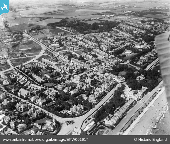
EPW001917 ENGLAND (1920). View of Felixstowe, Felixstowe, 1920

© Hawlfraint cyfranwyr OpenStreetMap a thrwyddedwyd gan yr OpenStreetMap Foundation. 2025. Trwyddedir y gartograffeg fel CC BY-SA.

Delweddau cyfagos (7)

EPW001917
  0° 0m
EAW038360
  163° 183m
EPW001916
  48° 199m
EPW039283
  121° 213m
EPW001915
  100° 222m
EPW016541
  194° 231m
EAW038358
  194° 235m

Manylion

Pennawd [EPW001917] View of Felixstowe, Felixstowe, 1920
Cyfeirnod EPW001917
Dyddiad June-1920
Dolen
Enw lle FELIXSTOWE
Plwyf FELIXSTOWE
Ardal
Gwlad ENGLAND
Dwyreiniad / Gogleddiad 630335, 234561
Hydred / Lledred 1.3530729645159, 51.961302300594
Cyfeirnod Grid Cenedlaethol TM303346

Pinnau

My house - 'The Beeches' 14 Croutel Road. It and the neighbouring house "The Hollies" (no. 12) were build on land given/sold to Mr Parker of the Dock Company by GE Pretyman, Tomline's heir. The houses were then built by the East Coast Development Company who were responsible for so much of the development of Felixstowe at that time. They were destined for Mr Parker's two sons Henry (no 12) and Edward (no 14). The houses had to be identical in all ways so as not to show favour to either son. Henry's son Victor was killed in battle in 1918 at the age of 18 and is commemorated on the Felixstowe War Memorial. I am surprised at the lack of development in this part of Felixstowe by 1920, it looks almost rural. Maybe Mr Parker thought he would be buying on the edge of town! Our house has quite an interesting history after this, it was owned by Fisons at one point when their headquarters were at Harvest House. We are fortunate to have copies of all the old deeds going back to 1900 when the land was first made available from Tomline's estate.

helenjanesmith
Saturday 24th of November 2012 09:24:40 AM

Cyfraniadau Grŵp

So thrilled to see my house near the boating lake in 1921 and to find it has changed so little!

oldunsees
Monday 2nd of July 2012 06:28:03 PM