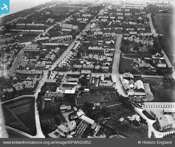
EPW001852 ENGLAND (1920). Church Road and St Edmund's Church, Hunstanton, 1920
    © Hawlfraint cyfranwyr OpenStreetMap a thrwyddedwyd gan yr OpenStreetMap Foundation. 2025. Trwyddedir y gartograffeg fel CC BY-SA.
  
Delweddau cyfagos (5)
Manylion
| Pennawd | [EPW001852] Church Road and St Edmund's Church, Hunstanton, 1920 | 
| Cyfeirnod | EPW001852 | 
| Dyddiad | July-1920 | 
| Dolen | |
| Enw lle | HUNSTANTON | 
| Plwyf | HUNSTANTON | 
| Ardal | |
| Gwlad | ENGLAND | 
| Dwyreiniad / Gogleddiad | 567541, 340866 | 
| Hydred / Lledred | 0.49342392183435, 52.938684043748 | 
| Cyfeirnod Grid Cenedlaethol | TF675409 | 
 
             
  ![[EPW001852] Church Road and St Edmund's Church, Hunstanton, 1920](http://britainfromabove.org.uk/sites/all/libraries/aerofilms-images/public/100x100/EPW/001/EPW001852.jpg) 
  
                                          ![[EPW021524] Church Street and environs, Hunstanton, 1928](http://britainfromabove.org.uk/sites/all/libraries/aerofilms-images/public/100x100/EPW/021/EPW021524.jpg) 
 ![[EAW050930] The Pier, Railway Station and town centre, Hunstanton, 1953](http://britainfromabove.org.uk/sites/all/libraries/aerofilms-images/public/100x100/EAW/050/EAW050930.jpg) 
 ![[EAW050929] The Pier and town centre, Hunstanton, 1953](http://britainfromabove.org.uk/sites/all/libraries/aerofilms-images/public/100x100/EAW/050/EAW050929.jpg) 
 ![[EPW021526] The pier and the town, Hunstanton, 1928](http://britainfromabove.org.uk/sites/all/libraries/aerofilms-images/public/100x100/EPW/021/EPW021526.jpg) 
  Lynfield House School
 Lynfield House School