
EPW001849 ENGLAND (1920). Hunstanton Lighthouse, Hunstanton, 1920

© Hawlfraint cyfranwyr OpenStreetMap a thrwyddedwyd gan yr OpenStreetMap Foundation. 2026. Trwyddedir y gartograffeg fel CC BY-SA.
Delweddau cyfagos (3)
EPW001849

EPW001997

EAW008203

Manylion
| Pennawd | [EPW001849] Hunstanton Lighthouse, Hunstanton, 1920 |
| Cyfeirnod | EPW001849 |
| Dyddiad | June-1920 |
| Dolen | |
| Enw lle | HUNSTANTON |
| Plwyf | HUNSTANTON |
| Ardal | |
| Gwlad | ENGLAND |
| Dwyreiniad / Gogleddiad | 567625, 342065 |
| Hydred / Lledred | 0.49529269246309, 52.949426964857 |
| Cyfeirnod Grid Cenedlaethol | TF676421 |
Pinnau
Byddwch y cyntaf i ychwanegu sylw at y ddelwedd hon!
Cyfraniadau Grŵp
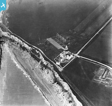
First World War wireless station |
Lynda Tubbs |
Thursday 10th of July 2014 03:09:03 PM |
The lighthouse & Coast Guard Tower are still there but are now (I think) holiday lets. The row of cottages are also still there but at the end of that short road is now the entrance to the large clifftop car park and a cafe. |

melgibbs |
Sunday 23rd of June 2013 09:40:41 PM |
The aerial masts next to the lighthouse were part of a wireless intercept station set up in WW1 by Colonel Richard Hippisley. In addition to evesdropping on German military wireless transmissions he also plotted the locations of the transmitters by direction finding. This process was used extensively in WW2 but this station was possibly the first or one of the first in the world. |

stanames |
Sunday 19th of August 2012 08:14:09 PM |