
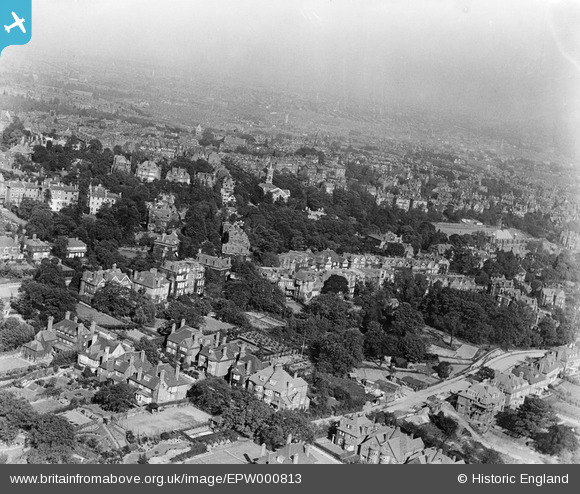
EPW000813 ENGLAND (1920). General view over Hampstead, Hampstead, from the west, 1920
© Hawlfraint cyfranwyr OpenStreetMap a thrwyddedwyd gan yr OpenStreetMap Foundation. 2026. Trwyddedir y gartograffeg fel CC BY-SA.
Delweddau cyfagos (4)
EPW000813

EAW014554

EAW000618

EAW000615

Manylion
| Pennawd | [EPW000813] General view over Hampstead, Hampstead, from the west, 1920 |
| Cyfeirnod | EPW000813 |
| Dyddiad | May-1920 |
| Dolen | |
| Enw lle | HAMPSTEAD |
| Plwyf | |
| Ardal | |
| Gwlad | ENGLAND |
| Dwyreiniad / Gogleddiad | 525794, 185655 |
| Hydred / Lledred | -0.18530114999103, 51.555258906067 |
| Cyfeirnod Grid Cenedlaethol | TQ258857 |
Pinnau

Class31 |
Wednesday 22nd of October 2014 07:57:09 AM | |

Andrew Holmes |
Friday 29th of June 2012 05:11:36 PM | |
|
Andrew Holmes |
Friday 29th of June 2012 05:09:35 PM | |
|
S Hope |
Thursday 28th of June 2012 12:41:29 PM |

Cyfraniadau Grŵp

St John-at-Hampstead Parish Church, 21/10/2014 |
Class31 |
Wednesday 22nd of October 2014 07:58:52 AM |

St John-at-Hampstead Parish Church, 21/10/2014 |
Class31 |
Wednesday 22nd of October 2014 07:58:24 AM |

St John-at-Hampstead Parish Church, 21/10/2014 |
Class31 |
Wednesday 22nd of October 2014 07:57:57 AM |
Hampstead Parish Church with the distinctive tower is a little way up from the centre. The area in the bottom half is therefore Frognal |
S Hope |
Thursday 28th of June 2012 12:26:57 PM |