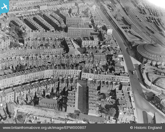
EPW000807 ENGLAND (1920). Chapells Piano Factory and Chalk Farm Road area, Camden, 1920
    © Hawlfraint cyfranwyr OpenStreetMap a thrwyddedwyd gan yr OpenStreetMap Foundation. 2025. Trwyddedir y gartograffeg fel CC BY-SA.
  
Delweddau cyfagos (23)
Manylion
| Pennawd | [EPW000807] Chapells Piano Factory and Chalk Farm Road area, Camden, 1920 | 
| Cyfeirnod | EPW000807 | 
| Dyddiad | May-1920 | 
| Dolen | |
| Enw lle | CAMDEN TOWN | 
| Plwyf | |
| Ardal | |
| Gwlad | ENGLAND | 
| Dwyreiniad / Gogleddiad | 528269, 184442 | 
| Hydred / Lledred | -0.15005912039503, 51.54379935618 | 
| Cyfeirnod Grid Cenedlaethol | TQ283844 | 
Pinnau
|  Ferdinand Street, NW1 |   billyfern | Wednesday 2nd of July 2014 04:35:43 PM | 
|  Regents Park Road, NW1 |   billyfern | Wednesday 2nd of July 2014 04:35:13 PM | 
|  Belmont Street, NW1 |   billyfern | Wednesday 2nd of July 2014 04:34:39 PM | 
|  Haverstock Hill, NW3 |   billyfern | Wednesday 2nd of July 2014 04:33:58 PM | 
|  Adelaide Road, NW3 |   billyfern | Wednesday 2nd of July 2014 04:33:36 PM | 
|  Chalk Farm Underground Station, Adelaide Road & Haverstock Hill, NW1 / NW3 |   billyfern | Wednesday 2nd of July 2014 04:33:04 PM | 
|  Chalk Farm Road, NW1 |   billyfern | Wednesday 2nd of July 2014 04:32:40 PM | 
|  Crogsland Road | Class31 | Tuesday 15th of October 2013 09:09:35 AM | 
|  "W&A Gilbey"
"Excise Bond No 3"
The firm of W&A Gilbey used the Roundhouse as a bonded warehouse from 1871. |   FermePark | Saturday 16th of March 2013 10:39:22 PM | 
 
             
  ![[EPW000807] Chapells Piano Factory and Chalk Farm Road area, Camden, 1920](http://britainfromabove.org.uk/sites/all/libraries/aerofilms-images/public/100x100/EPW/000/EPW000807.jpg) 
  
                                          ![[EPW000433] Camden Goods Yard and the Gilbey Warehouse, London, 1920](http://britainfromabove.org.uk/sites/all/libraries/aerofilms-images/public/100x100/EPW/000/EPW000433.jpg) 
 ![[EPW000803] Chapells Piano Factory and Chalk Farm Road area, Camden, 1920](http://britainfromabove.org.uk/sites/all/libraries/aerofilms-images/public/100x100/EPW/000/EPW000803.jpg) 
 ![[EPW000806] Camden Goods Yard and Chapells Piano Factory, Camden, 1920](http://britainfromabove.org.uk/sites/all/libraries/aerofilms-images/public/100x100/EPW/000/EPW000806.jpg) 
 ![[EPW000804] Camden Goods Yard and Chapells Piano Factory, Camden, 1920](http://britainfromabove.org.uk/sites/all/libraries/aerofilms-images/public/100x100/EPW/000/EPW000804.jpg) 
 ![[EPW000437] Chappell Piano Factory, Chalk Farm, London, 1920](http://britainfromabove.org.uk/sites/all/libraries/aerofilms-images/public/100x100/EPW/000/EPW000437.jpg) 
 ![[EPW000434] Chappell Piano Factory, Chalk Farm, London, 1920](http://britainfromabove.org.uk/sites/all/libraries/aerofilms-images/public/100x100/EPW/000/EPW000434.jpg) 
 ![[EPW000808] Chapells Piano Factory and Prince of Wales Road area, Camden, 1920](http://britainfromabove.org.uk/sites/all/libraries/aerofilms-images/public/100x100/EPW/000/EPW000808.jpg) 
 ![[EPW058590] Eton Rise, Eton Place, Chalk Farm Road and environs, Maitland Park, 1938](http://britainfromabove.org.uk/sites/all/libraries/aerofilms-images/public/100x100/EPW/058/EPW058590.jpg) 
 ![[EPW056359] Eton Place Flat Block under construction, Camden Town, 1938](http://britainfromabove.org.uk/sites/all/libraries/aerofilms-images/public/100x100/EPW/056/EPW056359.jpg) 
 ![[EPW060330] Eton Rise, Eton Hall, Eton Place, Prince of Wales Road and environs, Camden, 1939](http://britainfromabove.org.uk/sites/all/libraries/aerofilms-images/public/100x100/EPW/060/EPW060330.jpg) 
 ![[EPW056363] Eton Place Flat Block under construction, Camden Town, 1938](http://britainfromabove.org.uk/sites/all/libraries/aerofilms-images/public/100x100/EPW/056/EPW056363.jpg) 
 ![[EAW000621] A cityscape over Kentish Town including Chalk Farm Station, Camden Town, 1946](http://britainfromabove.org.uk/sites/all/libraries/aerofilms-images/public/100x100/EAW/000/EAW000621.jpg) 
 ![[EPW056365] Eton Place Flat Block under construction, Camden Town, 1938](http://britainfromabove.org.uk/sites/all/libraries/aerofilms-images/public/100x100/EPW/056/EPW056365.jpg) 
 ![[EPW058591] Eton Rise, Eton Place, Prince of Wales Road and environs, Maitland Park, 1938](http://britainfromabove.org.uk/sites/all/libraries/aerofilms-images/public/100x100/EPW/058/EPW058591.jpg) 
 ![[EPW058592] Eton Rise, Eton Place, Queen's Crescent and environs, Maitland Park, 1938](http://britainfromabove.org.uk/sites/all/libraries/aerofilms-images/public/100x100/EPW/058/EPW058592.jpg) 
 ![[EPW056358] Eton Place Flat Block under construction, Camden Town, 1938](http://britainfromabove.org.uk/sites/all/libraries/aerofilms-images/public/100x100/EPW/056/EPW056358.jpg) 
 ![[EPW058594] Eton Rise, Eton Place, Prince of Wales Road and environs, Maitland Park, 1938](http://britainfromabove.org.uk/sites/all/libraries/aerofilms-images/public/100x100/EPW/058/EPW058594.jpg) 
 ![[EPW060331] Eton Rise, Eton Hall, Eton Place and environs, Camden, 1939](http://britainfromabove.org.uk/sites/all/libraries/aerofilms-images/public/100x100/EPW/060/EPW060331.jpg) 
 ![[EPW060306] Blocks of flats on Eton College Road (Eton Rise, Eton Hall and Eton Place), Maitland Park, 1938](http://britainfromabove.org.uk/sites/all/libraries/aerofilms-images/public/100x100/EPW/060/EPW060306.jpg) 
 ![[EPW058477] Eton Rise, Eton Place, Prince of Wales Road and environs, Maitland Park, 1938](http://britainfromabove.org.uk/sites/all/libraries/aerofilms-images/public/100x100/EPW/058/EPW058477.jpg) 
 ![[EPW060332] St Saviour's Church, Eton Rise, Eton Hall, Eton Place and environs, Camden, 1939](http://britainfromabove.org.uk/sites/all/libraries/aerofilms-images/public/100x100/EPW/060/EPW060332.jpg) 
 ![[EPW060305] Blocks of flats on Eton College Road (Eton Rise, Eton Hall and Eton Place), Maitland Park, 1938](http://britainfromabove.org.uk/sites/all/libraries/aerofilms-images/public/100x100/EPW/060/EPW060305.jpg)