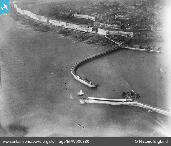
EPW000380 ENGLAND (1920). Ramsgate Harbour, Kent, 1920
© Hawlfraint cyfranwyr OpenStreetMap a thrwyddedwyd gan yr OpenStreetMap Foundation. 2026. Trwyddedir y gartograffeg fel CC BY-SA.
Delweddau cyfagos (19)
Manylion
| Pennawd | [EPW000380] Ramsgate Harbour, Kent, 1920 |
| Cyfeirnod | EPW000380 |
| Dyddiad | April-1920 |
| Dolen | |
| Enw lle | RAMSGATE |
| Plwyf | RAMSGATE |
| Ardal | |
| Gwlad | ENGLAND |
| Dwyreiniad / Gogleddiad | 638322, 164319 |
| Hydred / Lledred | 1.4212756987186, 51.327443170923 |
| Cyfeirnod Grid Cenedlaethol | TR383643 |


![[EPW000380] Ramsgate Harbour, Kent, 1920](http://britainfromabove.org.uk/sites/all/libraries/aerofilms-images/public/100x100/EPW/000/EPW000380.jpg)
![[EPW000375] Ramsgate Harbour, Ramsgate, 1920](http://britainfromabove.org.uk/sites/all/libraries/aerofilms-images/public/100x100/EPW/000/EPW000375.jpg)
![[EPW000595] The Royal Harbour, Ramsgate, from the south-west, 1920](http://britainfromabove.org.uk/sites/all/libraries/aerofilms-images/public/100x100/EPW/000/EPW000595.jpg)
![[EPW042862] The Royal Harbour and the town, Ramsgate, from the south, 1933](http://britainfromabove.org.uk/sites/all/libraries/aerofilms-images/public/100x100/EPW/042/EPW042862.jpg)
![[EAW020488] The town and harbour, Ramsgate, from the south-west, 1948](http://britainfromabove.org.uk/sites/all/libraries/aerofilms-images/public/100x100/EAW/020/EAW020488.jpg)
![[EAW008997] Royal Harbour and the town, Ramsgate, from the south, 1947](http://britainfromabove.org.uk/sites/all/libraries/aerofilms-images/public/100x100/EAW/008/EAW008997.jpg)
![[EAW020487] The town and harbour, Ramsgate, from the south-east, 1948](http://britainfromabove.org.uk/sites/all/libraries/aerofilms-images/public/100x100/EAW/020/EAW020487.jpg)
![[EAW009010] Royal Harbour and the town, Ramsgate, 1947](http://britainfromabove.org.uk/sites/all/libraries/aerofilms-images/public/100x100/EAW/009/EAW009010.jpg)
![[EAW696658] Western Ferry Terminal, Ramsgate, 2003](http://britainfromabove.org.uk/sites/all/libraries/aerofilms-images/public/100x100/EAW/696/EAW696658.jpg)
![[EPW039354] The Royal Harbour and Basin, Ramsgate, 1932](http://britainfromabove.org.uk/sites/all/libraries/aerofilms-images/public/100x100/EPW/039/EPW039354.jpg)
![[EAW009008] Royal Harbour and the town, Ramsgate, 1947](http://britainfromabove.org.uk/sites/all/libraries/aerofilms-images/public/100x100/EAW/009/EAW009008.jpg)
![[EAW006626] The Royal Harbour and town, Ramsgate, from the south, 1947](http://britainfromabove.org.uk/sites/all/libraries/aerofilms-images/public/100x100/EAW/006/EAW006626.jpg)
![[EAW008998] Royal Harbour and the town, Ramsgate, from the south, 1947](http://britainfromabove.org.uk/sites/all/libraries/aerofilms-images/public/100x100/EAW/008/EAW008998.jpg)
![[EAW009007] Royal Harbour and the town, Ramsgate, 1947](http://britainfromabove.org.uk/sites/all/libraries/aerofilms-images/public/100x100/EAW/009/EAW009007.jpg)
![[EAW009009] Royal Harbour and the town, Ramsgate, 1947](http://britainfromabove.org.uk/sites/all/libraries/aerofilms-images/public/100x100/EAW/009/EAW009009.jpg)
![[EPW000598] The Basin and Royal Harbour, Ramsgate, 1920](http://britainfromabove.org.uk/sites/all/libraries/aerofilms-images/public/100x100/EPW/000/EPW000598.jpg)
![[EAW008999] Royal Harbour and the town, Ramsgate, 1947](http://britainfromabove.org.uk/sites/all/libraries/aerofilms-images/public/100x100/EAW/008/EAW008999.jpg)
![[EPW000091] Royal Harbour, Ramsgate, 1920](http://britainfromabove.org.uk/sites/all/libraries/aerofilms-images/public/100x100/EPW/000/EPW000091.jpg)
![[EAW009006] Royal Harbour and the town, Ramsgate, 1947](http://britainfromabove.org.uk/sites/all/libraries/aerofilms-images/public/100x100/EAW/009/EAW009006.jpg)
