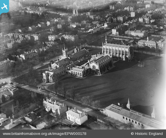
EPW000178 ENGLAND (1920). Cheltenham College, Cheltenham, 1920
© Hawlfraint cyfranwyr OpenStreetMap a thrwyddedwyd gan yr OpenStreetMap Foundation. 2026. Trwyddedir y gartograffeg fel CC BY-SA.
Delweddau cyfagos (13)
Manylion
| Pennawd | [EPW000178] Cheltenham College, Cheltenham, 1920 |
| Cyfeirnod | EPW000178 |
| Dyddiad | February-1920 |
| Dolen | |
| Enw lle | CHELTENHAM |
| Plwyf | |
| Ardal | |
| Gwlad | ENGLAND |
| Dwyreiniad / Gogleddiad | 394877, 221473 |
| Hydred / Lledred | -2.0744513801037, 51.891348645651 |
| Cyfeirnod Grid Cenedlaethol | SO949215 |
Pinnau

Class31 |
Saturday 28th of September 2013 09:17:13 PM | |

Class31 |
Saturday 28th of September 2013 09:12:47 PM | |

Class31 |
Saturday 28th of September 2013 09:04:59 PM | |

John Stephenson |
Friday 21st of June 2013 04:31:02 PM | |

John Stephenson |
Friday 21st of June 2013 04:30:28 PM | |

John Stephenson |
Friday 21st of June 2013 04:29:25 PM | |

John Stephenson |
Friday 21st of June 2013 04:28:54 PM | |

John Stephenson |
Friday 21st of June 2013 04:28:29 PM | |

John Stephenson |
Friday 21st of June 2013 04:28:09 PM |
Cyfraniadau Grŵp
Detail at west end of College chapel 27/09/2013 |

Class31 |
Saturday 28th of September 2013 09:29:49 PM |
College war memorial 27/09/2013 |

Class31 |
Saturday 28th of September 2013 09:22:59 PM |
Facade looking east 27/09/2013 |

Class31 |
Saturday 28th of September 2013 09:20:59 PM |
Looking south east 27/09/2013 |

Class31 |
Saturday 28th of September 2013 09:19:31 PM |
This is Cheltenham Boys College - Now known as Cheltenham College. |

ctrengove |
Thursday 17th of May 2012 04:26:40 PM |


![[EPW000178] Cheltenham College, Cheltenham, 1920](http://britainfromabove.org.uk/sites/all/libraries/aerofilms-images/public/100x100/EPW/000/EPW000178.jpg)
![[EPW000174] Cheltenham College, Cheltenham, 1920](http://britainfromabove.org.uk/sites/all/libraries/aerofilms-images/public/100x100/EPW/000/EPW000174.jpg)
![[EAW006523] Cheltenham College, Cheltenham, 1947](http://britainfromabove.org.uk/sites/all/libraries/aerofilms-images/public/100x100/EAW/006/EAW006523.jpg)
![[EPW000175] Cheltenham College, Cheltenham, 1920](http://britainfromabove.org.uk/sites/all/libraries/aerofilms-images/public/100x100/EPW/000/EPW000175.jpg)
![[EPW024138] Cheltenham College, Cheltenham, 1928](http://britainfromabove.org.uk/sites/all/libraries/aerofilms-images/public/100x100/EPW/024/EPW024138.jpg)
![[EPW048207] Cheltenham College and the town, Cheltenham, 1935](http://britainfromabove.org.uk/sites/all/libraries/aerofilms-images/public/100x100/EPW/048/EPW048207.jpg)
![[EPW024139] Cheltenham College, Cheltenham, 1928](http://britainfromabove.org.uk/sites/all/libraries/aerofilms-images/public/100x100/EPW/024/EPW024139.jpg)
![[EPW048208] Cheltenham College and the town, Cheltenham, 1935](http://britainfromabove.org.uk/sites/all/libraries/aerofilms-images/public/100x100/EPW/048/EPW048208.jpg)
![[EAW006516] Cheltenham College and Playing Fields, Cheltenham, 1947](http://britainfromabove.org.uk/sites/all/libraries/aerofilms-images/public/100x100/EAW/006/EAW006516.jpg)
![[EPW024137] Cheltenham College, Cheltenham, 1928](http://britainfromabove.org.uk/sites/all/libraries/aerofilms-images/public/100x100/EPW/024/EPW024137.jpg)
![[EAW006515] Cheltenham College and Playing Fields, Cheltenham, 1947](http://britainfromabove.org.uk/sites/all/libraries/aerofilms-images/public/100x100/EAW/006/EAW006515.jpg)
![[EPR000385] Cheltenham College, Cheltenham, 1934. This image was marked by Aero Pictorial Ltd for photo editing.](http://britainfromabove.org.uk/sites/all/libraries/aerofilms-images/public/100x100/EPR/000/EPR000385.jpg)
![[EPW024134] Montpellier and Fairview, Cheltenham, from the south-west, 1928](http://britainfromabove.org.uk/sites/all/libraries/aerofilms-images/public/100x100/EPW/024/EPW024134.jpg)