
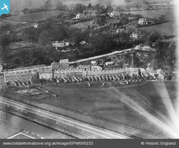
EPW000152 ENGLAND (1920). North Salts, Rye, 1920
© Hawlfraint cyfranwyr OpenStreetMap a thrwyddedwyd gan yr OpenStreetMap Foundation. 2026. Trwyddedir y gartograffeg fel CC BY-SA.
Delweddau cyfagos (2)
EPW000152

EPW026244

Manylion
| Pennawd | [EPW000152] North Salts, Rye, 1920 |
| Cyfeirnod | EPW000152 |
| Dyddiad | February-1920 |
| Dolen | |
| Enw lle | RYE |
| Plwyf | RYE |
| Ardal | |
| Gwlad | ENGLAND |
| Dwyreiniad / Gogleddiad | 592240, 120961 |
| Hydred / Lledred | 0.73750268133203, 50.955419880188 |
| Cyfeirnod Grid Cenedlaethol | TQ922210 |
Pinnau

DavidCamber |
Tuesday 9th of April 2013 11:12:05 PM | |
|
DavidCamber |
Tuesday 9th of April 2013 11:10:19 PM | |
|
DavidCamber |
Tuesday 9th of April 2013 11:09:22 PM | |
|
Dave Brunt |
Thursday 20th of December 2012 12:14:46 AM | |
|
Dave Brunt |
Thursday 20th of December 2012 12:13:36 AM | |

daviddb |
Monday 3rd of December 2012 05:17:02 PM | |

Class31 |
Wednesday 14th of November 2012 05:00:45 PM | |
Well Class 31 you would struggle to have read the sign board because having blown it up and played with in an image editor I found it was back wards and sends in ALES ! |
Dave Brunt |
Thursday 20th of December 2012 12:09:19 AM |
Not sure whether you'll see this comment as you posted some time ago & I'm new to the site. If you mean the sign over the pub (which is The Globe, Military Rd, Rye)then the last 2 words of 3 are "...Rye Ales." To the left, the building with large open doors is (or rather was then) a garage - in 1926 Miss G Eaton's Motor Garage, and she & her husband G.L.Eaton ran the pub too. Eaton may be the name on the central part of the board over the garage entrance. I can't quite make out the word before "...Rye Ales" at the moment. Puzzled at comments that the photo may be reversed ("flipped"?) as this view is perfectly OK and easily recognisable to anyone who knows Military Rd & Rye Hill. Waterloo Place ("Brassknocker Row" to old-timers!) is still there & is seen here from its back gardens. Several other well known houses are also easily recognisable even though it's a bit more built up now. The Globe is still there. Does this help? Peter. PS - Just seen the later posts re the correction, so I now realise it was reversed at the time you first saw it! |
Peter Ewart |
Sunday 9th of October 2016 10:32:08 PM |
|
MB |
Friday 19th of October 2012 10:16:22 AM | |
|
EastMarple1 |
Saturday 30th of June 2012 11:48:02 AM | |
|
EastMarple1 |
Saturday 30th of June 2012 11:47:24 AM | |
|
EastMarple1 |
Saturday 30th of June 2012 11:44:30 AM | |
Forge is a possibility. Note, on right of double doors, is a stable door - two horses maybe looking out? Therefore, could be a blacksmiths shop. And, to the left, maybe the local inn? |
ewnmcg |
Saturday 20th of October 2012 11:45:55 AM |
|
EastMarple1 |
Saturday 30th of June 2012 11:43:28 AM | |
|
EastMarple1 |
Saturday 30th of June 2012 11:42:40 AM | |
I think that this is a lake behind trees |
TomRobin |
Wednesday 14th of November 2012 10:44:01 PM |
Cyfraniadau Grŵp

North Salts, showing Spring Place and Waterloo Place with Mounsfield and Grove House in the background |
PaulS |
Thursday 6th of February 2014 12:42:51 PM |
OK the good folk at Britain from above are not going to like this but the image is backwards! But the good news is I found it! |
Dave Brunt |
Wednesday 2nd of January 2013 11:02:40 AM |
Very well done Dave. I've noticed a fair few flipped images on here. I guess it's worth thinking about the flipped version for any "hard to find" images - I'll certainly revisit a few that I'd given up on. Perhaps the "good folk" could include a "flip" button in the viewer, to give us a better chance of matching these ones. |
Tony D |
Thursday 20th of December 2012 12:10:57 PM |
Well Done Dave Brunt for getting this one with a twist ie flipped. I had given up on this one after many visits. I am very pleased that we all know where it is as it puts another one to bed. Well done. |
Class31 |
Saturday 22nd of December 2012 08:21:17 PM |
Thanks Dave, great spot and we'll arrange to swap the image around as well as get the correctly identified location information updated. Yours, Katy Britain from Above Cataloguing Team Leader |
Katy Whitaker |
Wednesday 2nd of January 2013 11:02:40 AM |
I would say this is a northern scene, probably Lancashire or Yorkshire, around Preston or the like. With the mix of stone terraces and Edwardian suburban villas |
TomRobin |
Wednesday 14th of November 2012 11:09:01 PM |
There are several things that do not add up about the Hythe - Sandgate suggestion for this picture. Firstly the only section of railway that ran beside the Royal Military Canal was the narrow gauge (15 inches) Romney Hythe and Dymchurch, open in 1927, so is not possible on grounds of date. Even if it was the right railway the buildings in the background are all wrong when considered against the location - map evidence from Hythe or by their building style. It is hard to identify if the buildings are brick or stone, but I tend towards them especially the terraces, being stone. In either case they look more like something characteristic of Derbyshire or Yorkshire rather than south-east England. I agree with Class31 about the railway on an embankment across a floodplain. The question about the water in front of the railway being a canal is settled by the telegraph pole that is situated in the water at the foot of the picture. It is clearly flood water. It would appear there are a number of different types of fencing in association with the railway. Immediately at the front of the embankment there appears to be a thorn hedge, possibly growing around a post and rail fence that becomes visible at the lower left-hand corner. The white gate stands in a post and wire fence. That this fence and the one across the lower right-hand corner of the picture are parallel to the railway might suggest they are related to its boundary marking in someway. The distances from the tracks might suggest land being taken in for a widening of the line…. a bit unusual by 1920 as most of the big quadrupling projects had taken place by then. A number of railways used hedges as boundaries at various locations - the London and South Western and Midland to name just two. However there is nothing here that is distinctively from just one company. The track is in good condition. The spacing of the sleepers (closer under the rail joints) suggests rails of 30ft in length carried on twelve sleepers. This might point to the Midland as the LSWR had eleven sleepers under a 30ft length of rail. A number of the houses appear to have external steps to back doors on the first floor (street level) as well as doors to cellars. The washing lines seem to extend into the neighbouring field…. perhaps by agreement with the landlord/landowner. To the left-hand side of the picture is a structure that appears to be a disused railway carriage, with four compartment doors (black windows) with ventilators and to each side windows with the blinds drawn down (white). It is hard to tell, but it could be an old Midland vehicle still in Crimson Lake (dark red). None of the above brings me any closer to knowing where the scene is located. Perhaps the number sequence is a red herring on this identification? |

Maurice |
Tuesday 21st of August 2012 04:56:44 PM |
Looking at the picture before and after (EPW000151 & EPW000153), this is very likely to be between Dover and Hythe along the coast. The water in the front looks like the stream between Hythe and Sandgate, but there isn't a railway there today. |
BenR |
Tuesday 21st of August 2012 10:09:19 AM |
There was a railway (The Hythe & Sandgate) in 1921, but it did not run alongside the Royal Military Canal at any point. |
Brian |
Tuesday 21st of August 2012 10:09:19 AM |
It is surprising that this photo remains unidentified. There are so many of us railway enthusiasts that we should have got this one by now. We have a straight double track standard gauge railway line on a slight embankment with what look like flooded borrow pits on either side of the line. Can anyone identify the lineside fencing as being that associated with a particular railway company. I suspect that this may be a coastal location with little to base this upon. The high quality villas may be built to take advantage of a view and are typical of seaside locations. The terraced housing is utilising the flat ground on the edge of the flood plain and avoiding the hills. Where is the photo taken? I've no idea. |
Class31 |
Wednesday 1st of August 2012 11:29:36 AM |