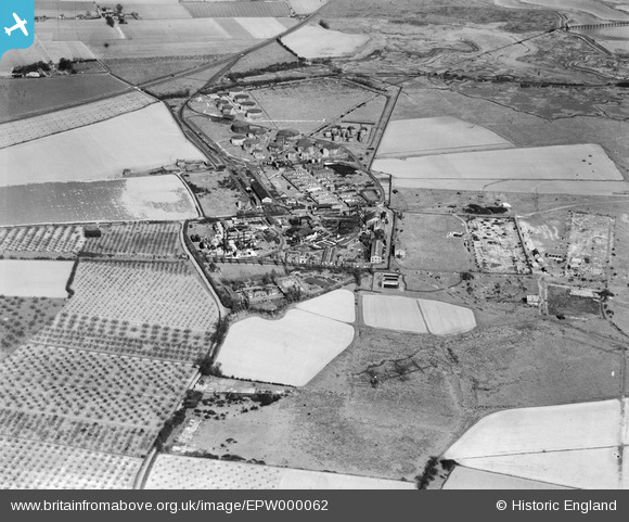
EPW000062 ENGLAND (1920). Berry Wiggins Oil Refinery, Kingsnorth, 1920
© Hawlfraint cyfranwyr OpenStreetMap a thrwyddedwyd gan yr OpenStreetMap Foundation. 2026. Trwyddedir y gartograffeg fel CC BY-SA.
Delweddau cyfagos (21)
Manylion
| Pennawd | [EPW000062] Berry Wiggins Oil Refinery, Kingsnorth, 1920 |
| Cyfeirnod | EPW000062 |
| Dyddiad | February-1920 |
| Dolen | |
| Enw lle | KINGSNORTH |
| Plwyf | HOO ST. WERBURGH |
| Ardal | |
| Gwlad | ENGLAND |
| Dwyreiniad / Gogleddiad | 580654, 173034 |
| Hydred / Lledred | 0.59890276768305, 51.426982849417 |
| Cyfeirnod Grid Cenedlaethol | TQ807730 |
Pinnau

JimP |
Wednesday 5th of February 2014 10:51:52 AM | |

JimP |
Wednesday 5th of February 2014 10:46:37 AM | |

JimP |
Wednesday 5th of February 2014 10:45:48 AM |
Cyfraniadau Grŵp
Definitely not 1920: see flight number AFL3692 dated 31st March 1946. This image follows on directly from EAW000063. |

Kentishman |
Tuesday 11th of August 2015 03:00:12 PM |
Was this photo taken in 1920? It shows the two large airship hangers demolished, while EPW047581, taken in 1935, shows them still standing. |

senusret |
Thursday 19th of March 2015 11:11:10 PM |
I believe this image should be the other way around. The site appears to be a mirror image of that shown in EPW000060a, and comparison with a map of the area (particularly the railway), would suggest that this image is flipped left-right. |

Tony D |
Monday 30th of July 2012 12:49:45 PM |

John Russell |
Wednesday 27th of June 2012 07:31:19 PM |


![[EPW000062] Berry Wiggins Oil Refinery, Kingsnorth, 1920](http://britainfromabove.org.uk/sites/all/libraries/aerofilms-images/public/100x100/EPW/000/EPW000062.jpg)
![[EAW000062] The Kingsnorth Petroleum Station, Kingsnorth, 1946. This image has been produced from a print.](http://britainfromabove.org.uk/sites/all/libraries/aerofilms-images/public/100x100/EAW/000/EAW000062.jpg)
![[EAW000059] The Kingsnorth Petroleum Station, Kingsnorth, 1946](http://britainfromabove.org.uk/sites/all/libraries/aerofilms-images/public/100x100/EAW/000/EAW000059.jpg)
![[EPW047585] The Berry Wiggins Oil Refinery, Kingsnorth, 1935](http://britainfromabove.org.uk/sites/all/libraries/aerofilms-images/public/100x100/EPW/047/EPW047585.jpg)
![[EAW000063] The Kingsnorth Petroleum Station, Kingsnorth, 1946](http://britainfromabove.org.uk/sites/all/libraries/aerofilms-images/public/100x100/EAW/000/EAW000063.jpg)
![[EAW032064] The Berry Wiggins Oil Refinery, Kingsnorth, 1950. This image was marked by Aerofilms Ltd for photo editing.](http://britainfromabove.org.uk/sites/all/libraries/aerofilms-images/public/100x100/EAW/032/EAW032064.jpg)
![[EAW032070] The Berry Wiggins Oil Refinery, Kingsnorth, 1950. This image was marked by Aerofilms Ltd for photo editing.](http://britainfromabove.org.uk/sites/all/libraries/aerofilms-images/public/100x100/EAW/032/EAW032070.jpg)
![[EPW047580] The Berry Wiggins Oil Refinery and environs, Kingsnorth, from the south-west, 1935](http://britainfromabove.org.uk/sites/all/libraries/aerofilms-images/public/100x100/EPW/047/EPW047580.jpg)
![[EPW047582] The Berry Wiggins Oil Refinery and environs, Kingsnorth, from the south-west, 1935](http://britainfromabove.org.uk/sites/all/libraries/aerofilms-images/public/100x100/EPW/047/EPW047582.jpg)
![[EPW047584] The Berry Wiggins Oil Refinery, Kingsnorth, 1935](http://britainfromabove.org.uk/sites/all/libraries/aerofilms-images/public/100x100/EPW/047/EPW047584.jpg)
![[EAW000061] The Kingsnorth Petroleum Station, Kingsnorth, 1946](http://britainfromabove.org.uk/sites/all/libraries/aerofilms-images/public/100x100/EAW/000/EAW000061.jpg)
![[EPW047586] The Berry Wiggins Oil Refinery, Kingsnorth, 1935](http://britainfromabove.org.uk/sites/all/libraries/aerofilms-images/public/100x100/EPW/047/EPW047586.jpg)
![[EPW047578] The Berry Wiggins Oil Refinery, Kingsnorth, 1935](http://britainfromabove.org.uk/sites/all/libraries/aerofilms-images/public/100x100/EPW/047/EPW047578.jpg)
![[EPW047579] The Berry Wiggins Oil Refinery, Kingsnorth, 1935](http://britainfromabove.org.uk/sites/all/libraries/aerofilms-images/public/100x100/EPW/047/EPW047579.jpg)
![[EAW000060] The Kingsnorth Petroleum Station, Kingsnorth, 1946. This image has been produced from a print.](http://britainfromabove.org.uk/sites/all/libraries/aerofilms-images/public/100x100/EAW/000/EAW000060.jpg)
![[EAW032068] The Berry Wiggins Oil Refinery, Kingsnorth, 1950. This image was marked by Aerofilms Ltd for photo editing.](http://britainfromabove.org.uk/sites/all/libraries/aerofilms-images/public/100x100/EAW/032/EAW032068.jpg)
![[EPW047583] The Berry Wiggins Oil Refinery, Kingsnorth, 1935](http://britainfromabove.org.uk/sites/all/libraries/aerofilms-images/public/100x100/EPW/047/EPW047583.jpg)
![[EPW000060A] Kingsnorth oil refinery, Kingsnorth, 1920](http://britainfromabove.org.uk/sites/all/libraries/aerofilms-images/public/100x100/EPW/000/EPW000060A.jpg)
![[EAW032067] The Berry Wiggins Oil Refinery, Kingsnorth, 1950. This image was marked by Aerofilms Ltd for photo editing.](http://britainfromabove.org.uk/sites/all/libraries/aerofilms-images/public/100x100/EAW/032/EAW032067.jpg)
![[EAW032069] The Berry Wiggins Oil Refinery and environs, Kingsnorth, 1950. This image was marked by Aerofilms Ltd for photo editing.](http://britainfromabove.org.uk/sites/all/libraries/aerofilms-images/public/100x100/EAW/032/EAW032069.jpg)
![[EPW047581] The Berry Wiggins Oil Refinery and environs, Kingsnorth, from the north-east, 1935](http://britainfromabove.org.uk/sites/all/libraries/aerofilms-images/public/100x100/EPW/047/EPW047581.jpg)
