
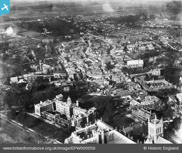
EPW000056 ENGLAND (1920). Castle Hill, Cambridge, 1920
© Hawlfraint cyfranwyr OpenStreetMap a thrwyddedwyd gan yr OpenStreetMap Foundation. 2026. Trwyddedir y gartograffeg fel CC BY-SA.
Delweddau cyfagos (6)
EPW000056

EPW025467
, Cambridge, 1928. This image has been produced from a copy-negative.")
EPW009789

EAW002914
, Cambridge, 1946")
EPW009787

EPW009786

Manylion
| Pennawd | [EPW000056] Castle Hill, Cambridge, 1920 |
| Cyfeirnod | EPW000056 |
| Dyddiad | January-1920 |
| Dolen | |
| Enw lle | CAMBRIDGE |
| Plwyf | |
| Ardal | |
| Gwlad | ENGLAND |
| Dwyreiniad / Gogleddiad | 544529, 259036 |
| Hydred / Lledred | 0.11552790723334, 52.210162465133 |
| Cyfeirnod Grid Cenedlaethol | TL445590 |
Pinnau

incony |
Friday 17th of February 2023 02:30:47 PM | |

Matt Aldred edob.mattaldred.com |
Saturday 9th of May 2020 08:18:40 PM | |
|
Atzan |
Tuesday 10th of November 2015 02:41:49 PM | |
|
Atzan |
Tuesday 10th of November 2015 02:33:52 PM | |
|
Simonsaorsa |
Saturday 1st of June 2013 10:13:06 PM | |
|
Simonsaorsa |
Saturday 1st of June 2013 10:12:45 PM | |
|
Birdman |
Tuesday 26th of June 2012 01:47:25 PM | |
|
rh8 |
Tuesday 26th of June 2012 12:26:19 AM |