
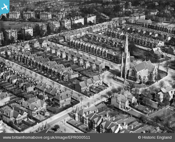
EPR000511 ENGLAND (1935). St Stephen's Church and environs, Ealing, 1935
© Hawlfraint cyfranwyr OpenStreetMap a thrwyddedwyd gan yr OpenStreetMap Foundation. 2026. Trwyddedir y gartograffeg fel CC BY-SA.
Delweddau cyfagos (2)
EPR000511

EPW010018

Manylion
| Pennawd | [EPR000511] St Stephen's Church and environs, Ealing, 1935 |
| Cyfeirnod | EPR000511 |
| Dyddiad | 1935 |
| Dolen | |
| Enw lle | EALING |
| Plwyf | |
| Ardal | |
| Gwlad | ENGLAND |
| Dwyreiniad / Gogleddiad | 516684, 181489 |
| Hydred / Lledred | -0.31803944818066, 51.519770856494 |
| Cyfeirnod Grid Cenedlaethol | TQ167815 |
Pinnau

JaneJ |
Wednesday 29th of April 2020 03:49:56 PM | |
|
JaneJ |
Wednesday 29th of April 2020 03:49:19 PM | |
|
JaneJ |
Wednesday 29th of April 2020 03:47:29 PM | |
|
JaneJ |
Wednesday 29th of April 2020 03:47:15 PM | |
|
JaneJ |
Wednesday 29th of April 2020 03:45:51 PM | |
|
JaneJ |
Wednesday 29th of April 2020 03:45:32 PM | |
|
JaneJ |
Wednesday 29th of April 2020 03:45:17 PM | |
|
JaneJ |
Wednesday 29th of April 2020 03:44:56 PM | |
|
JaneJ |
Wednesday 29th of April 2020 03:44:26 PM | |
|
JaneJ |
Wednesday 29th of April 2020 03:43:54 PM | |
|
JaneJ |
Wednesday 29th of April 2020 03:42:53 PM | |
|
JaneJ |
Wednesday 29th of April 2020 03:42:26 PM | |
|
JaneJ |
Wednesday 29th of April 2020 03:41:40 PM | |
|
JaneJ |
Wednesday 29th of April 2020 03:40:53 PM | |
|
JaneJ |
Wednesday 29th of April 2020 03:40:28 PM | |
|
JaneJ |
Wednesday 29th of April 2020 03:35:13 PM | |
|
JaneJ |
Wednesday 29th of April 2020 03:34:06 PM | |
|
JaneJ |
Wednesday 29th of April 2020 03:33:29 PM |