
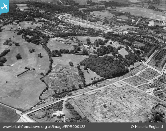
EPR000122 ENGLAND (1934). Shrewsbury Park and environs, Shooters Hill, 1934
© Hawlfraint cyfranwyr OpenStreetMap a thrwyddedwyd gan yr OpenStreetMap Foundation. 2026. Trwyddedir y gartograffeg fel CC BY-SA.
Delweddau cyfagos (3)
EPR000122

EPR000125

EPR000215

Manylion
| Pennawd | [EPR000122] Shrewsbury Park and environs, Shooters Hill, 1934 |
| Cyfeirnod | EPR000122 |
| Dyddiad | 4-July-1934 |
| Dolen | |
| Enw lle | SHOOTERS HILL |
| Plwyf | |
| Ardal | |
| Gwlad | ENGLAND |
| Dwyreiniad / Gogleddiad | 544342, 177169 |
| Hydred / Lledred | 0.078618484112521, 51.474557705855 |
| Cyfeirnod Grid Cenedlaethol | TQ443772 |
Pinnau

John W |
Friday 14th of April 2017 05:03:39 PM | |
|
John W |
Friday 14th of April 2017 04:51:26 PM | |
|
John W |
Friday 14th of April 2017 04:50:51 PM | |
|
John W |
Friday 14th of April 2017 04:50:12 PM | |
|
John W |
Friday 14th of April 2017 04:49:38 PM | |
|
John W |
Saturday 18th of June 2016 10:00:12 PM | |
|
John W |
Saturday 18th of June 2016 09:58:59 PM | |
|
John W |
Saturday 18th of June 2016 09:57:54 PM | |
|
John W |
Saturday 18th of June 2016 09:56:20 PM | |
|
John W |
Saturday 18th of June 2016 09:55:34 PM | |
|
John W |
Saturday 18th of June 2016 09:54:19 PM |