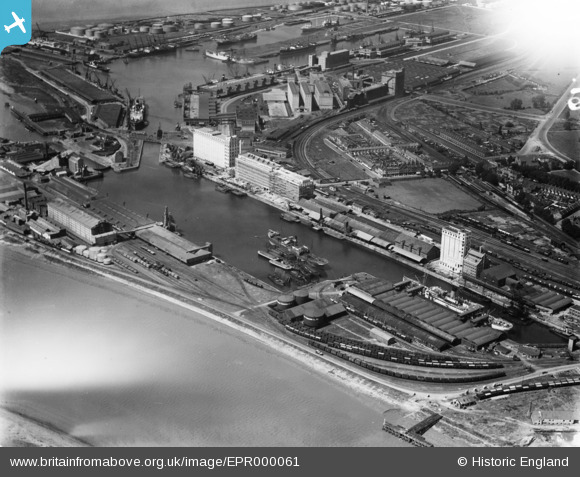
EPR000061 ENGLAND (1934). The docks, Avonmouth, 1934. This image has been affected by flare.
© Hawlfraint cyfranwyr OpenStreetMap a thrwyddedwyd gan yr OpenStreetMap Foundation. 2026. Trwyddedir y gartograffeg fel CC BY-SA.
Delweddau cyfagos (13)
Manylion
| Pennawd | [EPR000061] The docks, Avonmouth, 1934. This image has been affected by flare. |
| Cyfeirnod | EPR000061 |
| Dyddiad | 4-July-1934 |
| Dolen | |
| Enw lle | AVONMOUTH |
| Plwyf | |
| Ardal | |
| Gwlad | ENGLAND |
| Dwyreiniad / Gogleddiad | 351387, 177903 |
| Hydred / Lledred | -2.7003796128024, 51.497490738907 |
| Cyfeirnod Grid Cenedlaethol | ST514779 |
Pinnau

MB |
Monday 26th of September 2016 05:10:49 PM | |

MB |
Monday 26th of September 2016 05:09:55 PM | |

MB |
Monday 26th of September 2016 05:09:27 PM | |

MB |
Monday 26th of September 2016 05:08:49 PM | |

MB |
Monday 26th of September 2016 05:08:27 PM | |

MB |
Monday 26th of September 2016 05:08:01 PM | |

MB |
Monday 26th of September 2016 05:06:33 PM | |

MB |
Monday 26th of September 2016 05:04:50 PM | |

MB |
Monday 26th of September 2016 05:04:31 PM | |

MB |
Monday 26th of September 2016 05:04:07 PM | |

MB |
Monday 26th of September 2016 05:03:37 PM |


![[EPR000061] The docks, Avonmouth, 1934. This image has been affected by flare.](http://britainfromabove.org.uk/sites/all/libraries/aerofilms-images/public/100x100/EPR/000/EPR000061.jpg)
![[EPW027946] Avonmouth Dock, Avonmouth, 1929](http://britainfromabove.org.uk/sites/all/libraries/aerofilms-images/public/100x100/EPW/027/EPW027946.jpg)
![[EPW027954] Avonmouth Dock, Avonmouth, 1929. This image has been produced from a print.](http://britainfromabove.org.uk/sites/all/libraries/aerofilms-images/public/100x100/EPW/027/EPW027954.jpg)
![[EPR000059] Flour Mills alongside Avonmouth Dock, Avonmouth, 1934](http://britainfromabove.org.uk/sites/all/libraries/aerofilms-images/public/100x100/EPR/000/EPR000059.jpg)
![[EPR000058] Flour Mills alongside Avonmouth Dock, Avonmouth, 1934. This image has been affected by flare.](http://britainfromabove.org.uk/sites/all/libraries/aerofilms-images/public/100x100/EPR/000/EPR000058.jpg)
![[EAW002253] The Port of Bristol Authority Royal Edward Docks, Avonmouth, 1946. This image has been produced from a print.](http://britainfromabove.org.uk/sites/all/libraries/aerofilms-images/public/100x100/EAW/002/EAW002253.jpg)
![[EPW027951] Avonmouth Dock and environs, Avonmouth, 1929](http://britainfromabove.org.uk/sites/all/libraries/aerofilms-images/public/100x100/EPW/027/EPW027951.jpg)
![[EAW002072] Avonmouth Docks, Avonmouth, 1946. This image has been produced from a print.](http://britainfromabove.org.uk/sites/all/libraries/aerofilms-images/public/100x100/EAW/002/EAW002072.jpg)
![[EPW005487] Avonmouth Dock, Avonmouth, 1921](http://britainfromabove.org.uk/sites/all/libraries/aerofilms-images/public/100x100/EPW/005/EPW005487.jpg)
![[EPW019270] Avonmouth Dock, Avonmouth, 1927](http://britainfromabove.org.uk/sites/all/libraries/aerofilms-images/public/100x100/EPW/019/EPW019270.jpg)
![[EPW046975] Avonmouth Dock, Cellactite and British Uralite Ltd and environs, Avonmouth, from the north-west, 1935](http://britainfromabove.org.uk/sites/all/libraries/aerofilms-images/public/100x100/EPW/046/EPW046975.jpg)
![[EAW002071] Avonmouth Docks, Avonmouth, 1946. This image has been produced from a print.](http://britainfromabove.org.uk/sites/all/libraries/aerofilms-images/public/100x100/EAW/002/EAW002071.jpg)
![[EPW008649] The Avonmouth Oil Mills and Granaries, Avonmouth, 1923](http://britainfromabove.org.uk/sites/all/libraries/aerofilms-images/public/100x100/EPW/008/EPW008649.jpg)