
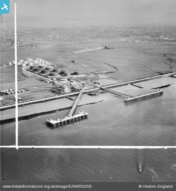
EAW053258 ENGLAND (1954). Jetties and oil depot at Hole Haven Wharf, Canvey Island, from the south-west, 1954. This image was marked by Aerofilms Ltd for photo editing.
© Hawlfraint cyfranwyr OpenStreetMap a thrwyddedwyd gan yr OpenStreetMap Foundation. 2026. Trwyddedir y gartograffeg fel CC BY-SA.
Delweddau cyfagos (11)
EAW053258

EAW053256

EAW053257

EAW053255

EAW053260

EAW053261

EAW021066

EAW053259

EPW055998

EPW056002

EAW053254

Manylion
| Pennawd | [EAW053258] Jetties and oil depot at Hole Haven Wharf, Canvey Island, from the south-west, 1954. This image was marked by Aerofilms Ltd for photo editing. |
| Cyfeirnod | EAW053258 |
| Dyddiad | 24-March-1954 |
| Dolen | |
| Enw lle | CANVEY ISLAND |
| Plwyf | CANVEY ISLAND |
| Ardal | |
| Gwlad | ENGLAND |
| Dwyreiniad / Gogleddiad | 577771, 181886 |
| Hydred / Lledred | 0.56192500821416, 51.50741722217 |
| Cyfeirnod Grid Cenedlaethol | TQ778819 |
Pinnau
Byddwch y cyntaf i ychwanegu sylw at y ddelwedd hon!