
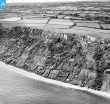
EAW050070 ENGLAND (1953). Cultivation plots (plats) on the cliffs near Branscombe Ebb, Branscombe, 1953

© Hawlfraint cyfranwyr OpenStreetMap a thrwyddedwyd gan yr OpenStreetMap Foundation. 2026. Trwyddedir y gartograffeg fel CC BY-SA.
Manylion
| Pennawd | [EAW050070] Cultivation plots (plats) on the cliffs near Branscombe Ebb, Branscombe, 1953 |
| Cyfeirnod | EAW050070 |
| Dyddiad | 25-June-1953 |
| Dolen | |
| Enw lle | BRANSCOMBE |
| Plwyf | BRANSCOMBE |
| Ardal | |
| Gwlad | ENGLAND |
| Dwyreiniad / Gogleddiad | 318778, 88057 |
| Hydred / Lledred | -3.1498900020879, 50.685913359364 |
| Cyfeirnod Grid Cenedlaethol | SY188881 |
Pinnau

JMB |
Saturday 25th of April 2015 07:31:48 PM |
Cyfraniadau Grŵp
RAF Branscombe WWII Chain Home radar station? |
JMB |
Saturday 25th of April 2015 07:32:04 PM |