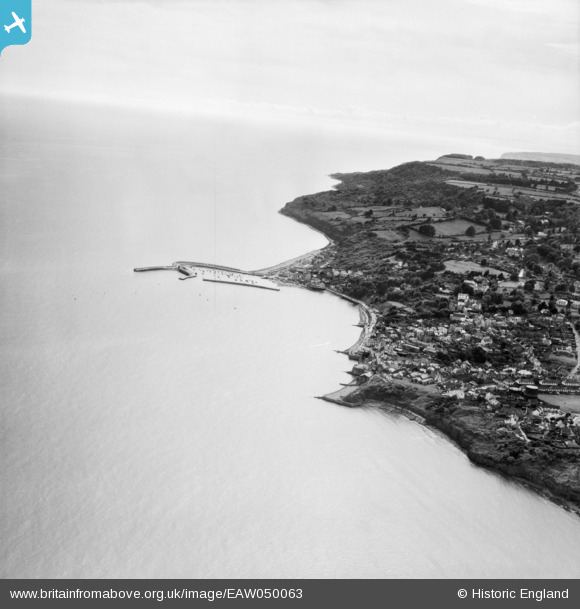
EAW050063 ENGLAND (1953). The town and harbour, Lyme Regis, from the north-east, 1953
© Hawlfraint cyfranwyr OpenStreetMap a thrwyddedwyd gan yr OpenStreetMap Foundation. 2026. Trwyddedir y gartograffeg fel CC BY-SA.
Delweddau cyfagos (18)
Manylion
| Pennawd | [EAW050063] The town and harbour, Lyme Regis, from the north-east, 1953 |
| Cyfeirnod | EAW050063 |
| Dyddiad | 25-June-1953 |
| Dolen | |
| Enw lle | LYME REGIS |
| Plwyf | LYME REGIS |
| Ardal | |
| Gwlad | ENGLAND |
| Dwyreiniad / Gogleddiad | 334489, 92074 |
| Hydred / Lledred | -2.9282113506804, 50.724018221485 |
| Cyfeirnod Grid Cenedlaethol | SY345921 |
Pinnau

redmist |
Wednesday 21st of September 2022 01:49:09 PM | |

redmist |
Wednesday 21st of September 2022 01:48:19 PM | |

Alan McFaden |
Friday 6th of June 2014 09:41:33 AM | |

Alan McFaden |
Friday 6th of June 2014 09:40:43 AM | |

Alan McFaden |
Friday 6th of June 2014 09:40:13 AM | |

Alan McFaden |
Friday 6th of June 2014 09:39:25 AM | |

Alan McFaden |
Friday 6th of June 2014 09:38:44 AM | |

Alan McFaden |
Friday 6th of June 2014 09:38:04 AM | |

Alan McFaden |
Friday 6th of June 2014 09:37:27 AM |
Cyfraniadau Grŵp
Just to say that the title of this photo should be 'The town and harbour, Lyme Regis' and not West Bay as shown. |

Class31 |
Wednesday 2nd of July 2014 09:29:58 AM |
Thank you. We've updated the Title. |
Hefin Meara |
Monday 9th of June 2014 08:39:16 AM |
Or we thought we had, seems not to have registered though. We're on the case. |
Katy Whitaker |
Wednesday 2nd of July 2014 09:29:58 AM |


![[EAW050063] The town and harbour, Lyme Regis, from the north-east, 1953](http://britainfromabove.org.uk/sites/all/libraries/aerofilms-images/public/100x100/EAW/050/EAW050063.jpg)
![[EPW024179] Church Cliffs and the town, Lyme Regis, from the south-east, 1928](http://britainfromabove.org.uk/sites/all/libraries/aerofilms-images/public/100x100/EPW/024/EPW024179.jpg)
![[EPW013474] The seafront, Lyme Regis, 1925. This image has been produced from a print.](http://britainfromabove.org.uk/sites/all/libraries/aerofilms-images/public/100x100/EPW/013/EPW013474.jpg)
![[EPW023896] The seafront and the town, Lyme Regis, from the south-east, 1928](http://britainfromabove.org.uk/sites/all/libraries/aerofilms-images/public/100x100/EPW/023/EPW023896.jpg)
![[EPW039713] The seafront from Long Ledge to Lucy's Ledge and the town, Lyme Regis, 1932](http://britainfromabove.org.uk/sites/all/libraries/aerofilms-images/public/100x100/EPW/039/EPW039713.jpg)
![[EAW033561] St Michael's Church, Church Street, Cobb Gate and environs, Lyme Regis, 1950. This image was marked by Aerofilms Ltd for photo editing.](http://britainfromabove.org.uk/sites/all/libraries/aerofilms-images/public/100x100/EAW/033/EAW033561.jpg)
![[EAW033564] St Michael's Church, the seafront and town, Lyme Regis, 1950. This image was marked by Aerofilms Ltd for photo editing.](http://britainfromabove.org.uk/sites/all/libraries/aerofilms-images/public/100x100/EAW/033/EAW033564.jpg)
![[EPW013475] The seafront and town, Lyme Regis, 1925. This image has been produced from a print.](http://britainfromabove.org.uk/sites/all/libraries/aerofilms-images/public/100x100/EPW/013/EPW013475.jpg)
![[EAW033663] St Michael's Church, Lyme Regis, 1950](http://britainfromabove.org.uk/sites/all/libraries/aerofilms-images/public/100x100/EAW/033/EAW033663.jpg)
![[EAW033662] Church Street, Lyme Regis, 1950](http://britainfromabove.org.uk/sites/all/libraries/aerofilms-images/public/100x100/EAW/033/EAW033662.jpg)
![[EAW033566] St Michael's Church, the seafront and town, Lyme Regis, 1950. This image was marked by Aerofilms Ltd for photo editing.](http://britainfromabove.org.uk/sites/all/libraries/aerofilms-images/public/100x100/EAW/033/EAW033566.jpg)
![[EPW013478] Cobb Gate and the town, Lyme Regis, 1925. This image has been produced from a print.](http://britainfromabove.org.uk/sites/all/libraries/aerofilms-images/public/100x100/EPW/013/EPW013478.jpg)
![[EAW033560] St Michael's Church, Church Street and environs, Lyme Regis, 1950. This image was marked by Aerofilms Ltd for photo editing.](http://britainfromabove.org.uk/sites/all/libraries/aerofilms-images/public/100x100/EAW/033/EAW033560.jpg)
![[EAW033559] St Michael's Church, Church Street, the Gables Hotel and environs, Lyme Regis, 1950. This image was marked by Aerofilms Ltd for photo editing.](http://britainfromabove.org.uk/sites/all/libraries/aerofilms-images/public/100x100/EAW/033/EAW033559.jpg)
![[EPW023891] The town and harbour, Lyme Regis, from the east, 1928](http://britainfromabove.org.uk/sites/all/libraries/aerofilms-images/public/100x100/EPW/023/EPW023891.jpg)
![[EAW033565] St Michael's Church and the Gables Hotel looking towards Anning Road, Lyme Regis, 1950. This image was marked by Aerofilms Ltd for photo editing.](http://britainfromabove.org.uk/sites/all/libraries/aerofilms-images/public/100x100/EAW/033/EAW033565.jpg)
![[EAW033562] Church Street and environs looking towards Anning Road, Lyme Regis, 1950](http://britainfromabove.org.uk/sites/all/libraries/aerofilms-images/public/100x100/EAW/033/EAW033562.jpg)
![[EAW033563] Church Street and environs looking towards Anning Road, Lyme Regis, 1950. This image was marked by Aerofilms Ltd for photo editing.](http://britainfromabove.org.uk/sites/all/libraries/aerofilms-images/public/100x100/EAW/033/EAW033563.jpg)


