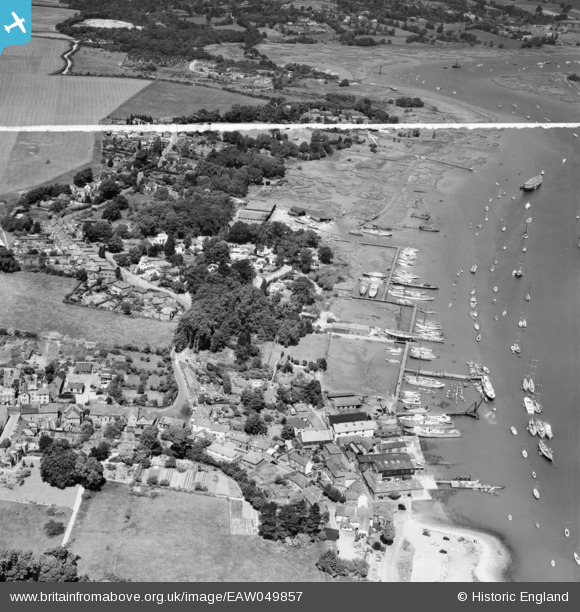
EAW049857 ENGLAND (1953). The village and waterfront, Hamble-le-Rice, 1953. This image was marked by Aerofilms Ltd for photo editing.
    © Hawlfraint cyfranwyr OpenStreetMap a thrwyddedwyd gan yr OpenStreetMap Foundation. 2025. Trwyddedir y gartograffeg fel CC BY-SA.
  
Delweddau cyfagos (9)
Manylion
| Pennawd | [EAW049857] The village and waterfront, Hamble-le-Rice, 1953. This image was marked by Aerofilms Ltd for photo editing. | 
| Cyfeirnod | EAW049857 | 
| Dyddiad | 9-July-1953 | 
| Dolen | |
| Enw lle | HAMBLE-LE-RICE | 
| Plwyf | HAMBLE-LE-RICE | 
| Ardal | |
| Gwlad | ENGLAND | 
| Dwyreiniad / Gogleddiad | 448383, 107060 | 
| Hydred / Lledred | -1.3124755057683, 50.860465850846 | 
| Cyfeirnod Grid Cenedlaethol | SU484071 | 
 
             
  ![[EAW049857] The village and waterfront, Hamble-le-Rice, 1953. This image was marked by Aerofilms Ltd for photo editing.](http://britainfromabove.org.uk/sites/all/libraries/aerofilms-images/public/100x100/EAW/049/EAW049857.jpg) 
  
                                          ![[EAW049861] The River Hamble, waterfront and village, Hamble-le-Rice, 1953](http://britainfromabove.org.uk/sites/all/libraries/aerofilms-images/public/100x100/EAW/049/EAW049861.jpg) 
 ![[EAW049859] The waterfront, Hamble-le-Rice, from the south-east, 1953. This image was marked by Aerofilms Ltd for photo editing.](http://britainfromabove.org.uk/sites/all/libraries/aerofilms-images/public/100x100/EAW/049/EAW049859.jpg) 
 ![[EAW049862] The River Hamble, waterfront and village, Hamble-le-Rice, 1953](http://britainfromabove.org.uk/sites/all/libraries/aerofilms-images/public/100x100/EAW/049/EAW049862.jpg) 
 ![[EAW049867] The waterfront and village, Hamble-le-Rice, from the east, 1953](http://britainfromabove.org.uk/sites/all/libraries/aerofilms-images/public/100x100/EAW/049/EAW049867.jpg) 
 ![[EAW049868] The River Hamble and Southampton Water, Hamble-le-Rice, 1953](http://britainfromabove.org.uk/sites/all/libraries/aerofilms-images/public/100x100/EAW/049/EAW049868.jpg) 
 ![[EAW049866] The waterfront and Hamble Airfield, Hamble-le-Rice, from the south-east, 1953. This image was marked by Aerofilms Ltd for photo editing.](http://britainfromabove.org.uk/sites/all/libraries/aerofilms-images/public/100x100/EAW/049/EAW049866.jpg) 
 ![[EAW049858] The waterfront and Hamble Airfield, Hamble-le-Rice, from the south-east, 1953. This image was marked by Aerofilms Ltd for photo editing.](http://britainfromabove.org.uk/sites/all/libraries/aerofilms-images/public/100x100/EAW/049/EAW049858.jpg) 
 ![[EAW049865] The River Hamble, waterfront and village, Hamble-le-Rice, from the north-east, 1953. This image was marked by Aerofilms Ltd for photo editing.](http://britainfromabove.org.uk/sites/all/libraries/aerofilms-images/public/100x100/EAW/049/EAW049865.jpg) 
  Two Fairmile D and Ex Kreigsmarine S-Boot under conversion to Houseboats.
 Two Fairmile D and Ex Kreigsmarine S-Boot under conversion to Houseboats. 