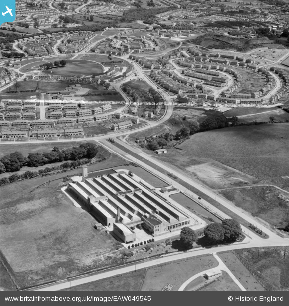
EAW049545 ENGLAND (1953). The Bush Radio Ltd Factory at Ernesettle and neighbouring housing development off Uxbridge Drive, Plymouth, 1953. This image was marked by Aerofilms Ltd for photo editing.
© Hawlfraint cyfranwyr OpenStreetMap a thrwyddedwyd gan yr OpenStreetMap Foundation. 2026. Trwyddedir y gartograffeg fel CC BY-SA.
Delweddau cyfagos (14)
Manylion
| Pennawd | [EAW049545] The Bush Radio Ltd Factory at Ernesettle and neighbouring housing development off Uxbridge Drive, Plymouth, 1953. This image was marked by Aerofilms Ltd for photo editing. |
| Cyfeirnod | EAW049545 |
| Dyddiad | 26-May-1953 |
| Dolen | |
| Enw lle | PLYMOUTH |
| Plwyf | |
| Ardal | |
| Gwlad | ENGLAND |
| Dwyreiniad / Gogleddiad | 244934, 59996 |
| Hydred / Lledred | -4.1830233283827, 50.418723647849 |
| Cyfeirnod Grid Cenedlaethol | SX449600 |
Pinnau
Allen T |
Saturday 2nd of August 2014 10:28:11 PM | |
Allen T |
Saturday 2nd of August 2014 10:26:35 PM | |
Allen T |
Saturday 2nd of August 2014 10:24:40 PM | |
Allen T |
Saturday 2nd of August 2014 10:23:49 PM | |
Allen T |
Saturday 2nd of August 2014 10:23:06 PM |


![[EAW049545] The Bush Radio Ltd Factory at Ernesettle and neighbouring housing development off Uxbridge Drive, Plymouth, 1953. This image was marked by Aerofilms Ltd for photo editing.](http://britainfromabove.org.uk/sites/all/libraries/aerofilms-images/public/100x100/EAW/049/EAW049545.jpg)
![[EAW049546] The Bush Radio Ltd Factory at Ernesettle, Plymouth, 1953. This image was marked by Aerofilms Ltd for photo editing.](http://britainfromabove.org.uk/sites/all/libraries/aerofilms-images/public/100x100/EAW/049/EAW049546.jpg)
![[EAW047184] The Bush Radio Ltd Works at Ernesettle, Plymouth, 1952. This image was marked by Aerofilms Ltd for photo editing.](http://britainfromabove.org.uk/sites/all/libraries/aerofilms-images/public/100x100/EAW/047/EAW047184.jpg)
![[EAW047186] The Bush Radio Ltd Works at Ernesettle, Plymouth, 1952. This image was marked by Aerofilms Ltd for photo editing.](http://britainfromabove.org.uk/sites/all/libraries/aerofilms-images/public/100x100/EAW/047/EAW047186.jpg)
![[EAW047187] The Bush Radio Ltd Works at Ernesettle, Plymouth, 1952. This image was marked by Aerofilms Ltd for photo editing.](http://britainfromabove.org.uk/sites/all/libraries/aerofilms-images/public/100x100/EAW/047/EAW047187.jpg)
![[EAW047188] The Bush Radio Ltd Works at Ernesettle, Plymouth, 1952. This image was marked by Aerofilms Ltd for photo editing.](http://britainfromabove.org.uk/sites/all/libraries/aerofilms-images/public/100x100/EAW/047/EAW047188.jpg)
![[EAW049549] The Bush Radio Ltd Factory and Tamerton Lake, Plymouth, from the south, 1953. This image was marked by Aerofilms Ltd for photo editing.](http://britainfromabove.org.uk/sites/all/libraries/aerofilms-images/public/100x100/EAW/049/EAW049549.jpg)
![[EAW047189] The Bush Radio Ltd Works at Ernesettle, Plymouth, 1952. This image was marked by Aerofilms Ltd for photo editing.](http://britainfromabove.org.uk/sites/all/libraries/aerofilms-images/public/100x100/EAW/047/EAW047189.jpg)
![[EAW047185] The Bush Radio Ltd Works at Ernesettle, Plymouth, 1952. This image was marked by Aerofilms Ltd for photo editing.](http://britainfromabove.org.uk/sites/all/libraries/aerofilms-images/public/100x100/EAW/047/EAW047185.jpg)
![[EAW049541] The Bush Radio Ltd Factory at Ernesettle and the Plymouth Corporation Sewage Works, Plymouth, 1953. This image was marked by Aerofilms Ltd for photo editing.](http://britainfromabove.org.uk/sites/all/libraries/aerofilms-images/public/100x100/EAW/049/EAW049541.jpg)
![[EAW049542] The Bush Radio Ltd Factory at Ernesettle, Plymouth, 1953. This image was marked by Aerofilms Ltd for photo editing.](http://britainfromabove.org.uk/sites/all/libraries/aerofilms-images/public/100x100/EAW/049/EAW049542.jpg)
![[EAW049543] The Bush Radio Ltd Factory at Ernesettle, Plymouth, 1953. This image was marked by Aerofilms Ltd for photo editing.](http://britainfromabove.org.uk/sites/all/libraries/aerofilms-images/public/100x100/EAW/049/EAW049543.jpg)
![[EAW049548] The Bush Radio Ltd Factory and RNAD (Royal Naval Armaments Depot) Ernesettle, Plymouth, 1953. This image was marked by Aerofilms Ltd for photo editing.](http://britainfromabove.org.uk/sites/all/libraries/aerofilms-images/public/100x100/EAW/049/EAW049548.jpg)
![[EAW049544] The Bush Radio Ltd Factory at Ernesettle and the Plymouth Corporation Sewage Works, Plymouth, 1953. This image was marked by Aerofilms Ltd for photo editing.](http://britainfromabove.org.uk/sites/all/libraries/aerofilms-images/public/100x100/EAW/049/EAW049544.jpg)