
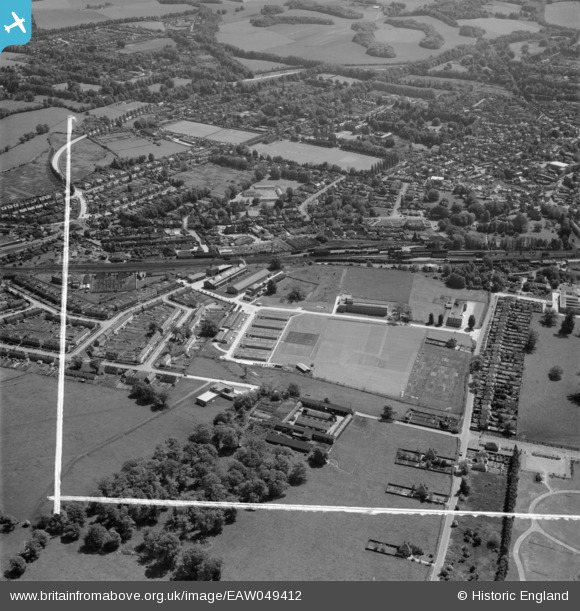
EAW049412 ENGLAND (1953). The British Coal Utilisation Research Association (BCURA) on Randalls Road and environs, Leatherhead, 1953. This image was marked by Aerofilms Ltd for photo editing.
© Hawlfraint cyfranwyr OpenStreetMap a thrwyddedwyd gan yr OpenStreetMap Foundation. 2026. Trwyddedir y gartograffeg fel CC BY-SA.
Delweddau cyfagos (12)
EAW049412
 on Randalls Road and environs, Leatherhead, 1953. This image was marked by Aerofilms Ltd for photo editing.")
EAW049413
 on Randalls Road and environs, Leatherhead, 1953. This image was marked by Aerofilms Ltd for photo editing.")
EAW049411
 on Randalls Road and environs, Leatherhead, 1953. This image was marked by Aerofilms Ltd for photo editing.")
EAW049418
 on Randalls Road and environs, Leatherhead, 1953. This image was marked by Aerofilms Ltd for photo editing.")
EAW049415
 on Randalls Road and environs, Leatherhead, 1953. This image was marked by Aerofilms Ltd for photo editing.")
EAW049414
 on Randalls Road and environs, Leatherhead, 1953. This image was marked by Aerofilms Ltd for photo editing.")
EAW024014

EAW024017

EAW024013

EAW024016

EAW024012

EPW057009

Manylion
| Pennawd | [EAW049412] The British Coal Utilisation Research Association (BCURA) on Randalls Road and environs, Leatherhead, 1953. This image was marked by Aerofilms Ltd for photo editing. |
| Cyfeirnod | EAW049412 |
| Dyddiad | 19-May-1953 |
| Dolen | |
| Enw lle | LEATHERHEAD |
| Plwyf | |
| Ardal | |
| Gwlad | ENGLAND |
| Dwyreiniad / Gogleddiad | 516201, 157082 |
| Hydred / Lledred | -0.33299796886232, 51.300480388051 |
| Cyfeirnod Grid Cenedlaethol | TQ162571 |
