
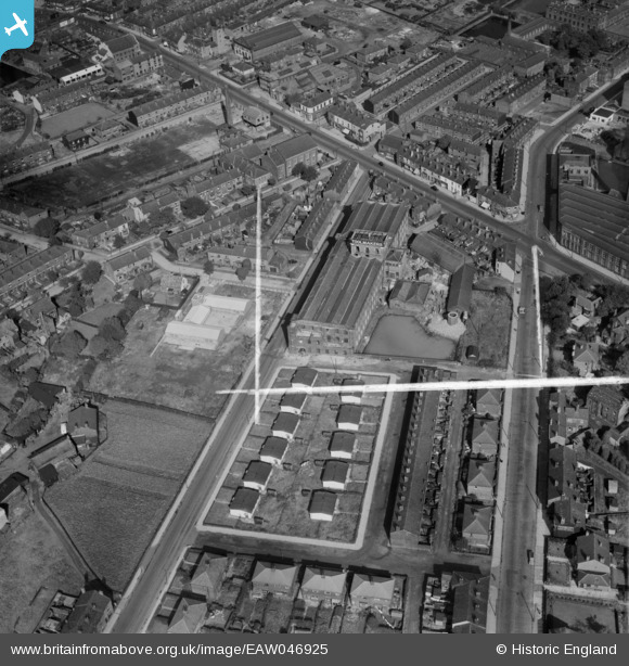
EAW046925 ENGLAND (1952). Silcoms Victoria Mill (Toolmakers), Farnworth, 1952. This image was marked by Aerofilms Ltd for photo editing.
© Hawlfraint cyfranwyr OpenStreetMap a thrwyddedwyd gan yr OpenStreetMap Foundation. 2026. Trwyddedir y gartograffeg fel CC BY-SA.
Delweddau cyfagos (19)
EAW046925
, Farnworth, 1952. This image was marked by Aerofilms Ltd for photo editing.")
EAW046928
, Farnworth, 1952. This image was marked by Aerofilms Ltd for photo editing.")
EAW046689

EAW046688

EAW046686

EAW046692

EPW018817

EAW046690

EAW046927
, Farnworth, 1952. This image was marked by Aerofilms Ltd for photo editing.")
EAW046924
, Farnworth, 1952. This image was marked by Aerofilms Ltd for photo editing.")
EAW046691

EAW046687

EAW046929
, Farnworth, 1952. This image was marked by Aerofilms Ltd for photo editing.")
EAW046923
 and Albert Road, Farnworth, 1952. This image was marked by Aerofilms Ltd for photo editing.")
EAW046684

EAW046926
, Farnworth, 1952. This image was marked by Aerofilms Ltd for photo editing.")
EAW046685

EAW046930
, Farnworth, 1952. This image was marked by Aerofilms Ltd for photo editing.")
EAW046693

Manylion
| Pennawd | [EAW046925] Silcoms Victoria Mill (Toolmakers), Farnworth, 1952. This image was marked by Aerofilms Ltd for photo editing. |
| Cyfeirnod | EAW046925 |
| Dyddiad | 13-September-1952 |
| Dolen | |
| Enw lle | FARNWORTH |
| Plwyf | |
| Ardal | |
| Gwlad | ENGLAND |
| Dwyreiniad / Gogleddiad | 373500, 405271 |
| Hydred / Lledred | -2.3999482705872, 53.543166535132 |
| Cyfeirnod Grid Cenedlaethol | SD735053 |
Pinnau

Landstrider2012 |
Wednesday 1st of October 2014 04:05:32 PM | |
|
Landstrider2012 |
Wednesday 1st of October 2014 04:02:34 PM | |
|
Landstrider2012 |
Wednesday 1st of October 2014 04:02:00 PM |