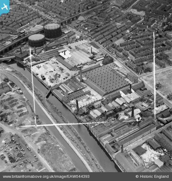
EAW044393 ENGLAND (1952). The British Screw Co Ltd Factory on Kirkstall Road and environs, Leeds, 1952. This image was marked by Aerofilms Ltd for photo editing.
© Hawlfraint cyfranwyr OpenStreetMap a thrwyddedwyd gan yr OpenStreetMap Foundation. 2026. Trwyddedir y gartograffeg fel CC BY-SA.
Delweddau cyfagos (15)
Manylion
| Pennawd | [EAW044393] The British Screw Co Ltd Factory on Kirkstall Road and environs, Leeds, 1952. This image was marked by Aerofilms Ltd for photo editing. |
| Cyfeirnod | EAW044393 |
| Dyddiad | 27-June-1952 |
| Dolen | |
| Enw lle | LEEDS |
| Plwyf | |
| Ardal | |
| Gwlad | ENGLAND |
| Dwyreiniad / Gogleddiad | 428178, 434062 |
| Hydred / Lledred | -1.5721131323019, 53.801880098017 |
| Cyfeirnod Grid Cenedlaethol | SE282341 |
Pinnau

redmist |
Tuesday 29th of November 2022 10:37:44 PM | |

redmist |
Tuesday 29th of November 2022 10:37:17 PM | |

redmist |
Tuesday 29th of November 2022 10:36:27 PM | |

spugs |
Thursday 14th of April 2016 11:29:56 PM | |

spugs |
Thursday 14th of April 2016 11:28:55 PM | |

spugs |
Thursday 14th of April 2016 11:25:38 PM | |

spugs |
Thursday 14th of April 2016 11:22:55 PM | |

spugs |
Wednesday 31st of December 2014 01:59:06 PM |


![[EAW044393] The British Screw Co Ltd Factory on Kirkstall Road and environs, Leeds, 1952. This image was marked by Aerofilms Ltd for photo editing.](http://britainfromabove.org.uk/sites/all/libraries/aerofilms-images/public/100x100/EAW/044/EAW044393.jpg)
![[EAW044390] The British Screw Co Ltd Factory on Kirkstall Road and environs, Leeds, 1952. This image was marked by Aerofilms Ltd for photo editing.](http://britainfromabove.org.uk/sites/all/libraries/aerofilms-images/public/100x100/EAW/044/EAW044390.jpg)
![[EAW044387] The British Screw Co Ltd Factory on Kirkstall Road and environs, Leeds, 1952. This image was marked by Aerofilms Ltd for photo editing.](http://britainfromabove.org.uk/sites/all/libraries/aerofilms-images/public/100x100/EAW/044/EAW044387.jpg)
![[EAW044391] The British Screw Co Ltd Factory on Kirkstall Road and environs, Leeds, 1952. This image was marked by Aerofilms Ltd for photo editing.](http://britainfromabove.org.uk/sites/all/libraries/aerofilms-images/public/100x100/EAW/044/EAW044391.jpg)
![[EAW044389] The British Screw Co Ltd Factory on Kirkstall Road and environs, Leeds, 1952. This image was marked by Aerofilms Ltd for photo editing.](http://britainfromabove.org.uk/sites/all/libraries/aerofilms-images/public/100x100/EAW/044/EAW044389.jpg)
![[EAW044388] The British Screw Co Ltd Factory on Kirkstall Road and environs, Leeds, 1952. This image was marked by Aerofilms Ltd for photo editing.](http://britainfromabove.org.uk/sites/all/libraries/aerofilms-images/public/100x100/EAW/044/EAW044388.jpg)
![[EAW044394] The British Screw Co Ltd Factory on Kirkstall Road and environs, Leeds, 1952. This image was marked by Aerofilms Ltd for photo editing.](http://britainfromabove.org.uk/sites/all/libraries/aerofilms-images/public/100x100/EAW/044/EAW044394.jpg)
![[EAW044392] The British Screw Co Ltd Factory on Kirkstall Road and environs, Leeds, 1952. This image was marked by Aerofilms Ltd for photo editing.](http://britainfromabove.org.uk/sites/all/libraries/aerofilms-images/public/100x100/EAW/044/EAW044392.jpg)
![[EAW044386] The British Screw Co Ltd Factory and other industrial buildings along Kirkstall Road, Leeds, 1952. This image was marked by Aerofilms Ltd for photo editing.](http://britainfromabove.org.uk/sites/all/libraries/aerofilms-images/public/100x100/EAW/044/EAW044386.jpg)
![[EAW035540] The Wilsons and Mathiesons Ltd Scotch Iron Foundry and the surrounding area, Armley, 1951. This image has been produced from a print marked by Aerofilms Ltd for photo editing.](http://britainfromabove.org.uk/sites/all/libraries/aerofilms-images/public/100x100/EAW/035/EAW035540.jpg)
![[EPW057177] The Jonas Woodhead and Sons Spring and Axle Works, Leeds, 1938](http://britainfromabove.org.uk/sites/all/libraries/aerofilms-images/public/100x100/EPW/057/EPW057177.jpg)
![[EPW057173] The Jonas Woodhead and Sons Spring and Axle Works, Leeds, 1938](http://britainfromabove.org.uk/sites/all/libraries/aerofilms-images/public/100x100/EPW/057/EPW057173.jpg)
![[EPW057175] The Jonas Woodhead and Sons Spring and Axle Works, Leeds, 1938](http://britainfromabove.org.uk/sites/all/libraries/aerofilms-images/public/100x100/EPW/057/EPW057175.jpg)
![[EPW057176] The Jonas Woodhead and Sons Spring and Axle Works, Leeds, 1938](http://britainfromabove.org.uk/sites/all/libraries/aerofilms-images/public/100x100/EPW/057/EPW057176.jpg)
![[EPW057174] The Jonas Woodhead and Sons Spring and Axle Works, Leeds, 1938](http://britainfromabove.org.uk/sites/all/libraries/aerofilms-images/public/100x100/EPW/057/EPW057174.jpg)