
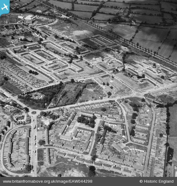
EAW044298 ENGLAND (1952). New housing under construction to the north and south of Ripon Way, Borehamwood, 1952
© Hawlfraint cyfranwyr OpenStreetMap a thrwyddedwyd gan yr OpenStreetMap Foundation. 2026. Trwyddedir y gartograffeg fel CC BY-SA.
Delweddau cyfagos (3)
EAW044298

EPW057943
 and eastern Borehamwood under construction, Borehamwood, from the south-west, 1938")
EAW046962

Manylion
| Pennawd | [EAW044298] New housing under construction to the north and south of Ripon Way, Borehamwood, 1952 |
| Cyfeirnod | EAW044298 |
| Dyddiad | 24-June-1952 |
| Dolen | |
| Enw lle | BOREHAMWOOD |
| Plwyf | ELSTREE AND BOREHAMWOOD |
| Ardal | |
| Gwlad | ENGLAND |
| Dwyreiniad / Gogleddiad | 520637, 196029 |
| Hydred / Lledred | -0.25608877648624, 51.649628989786 |
| Cyfeirnod Grid Cenedlaethol | TQ206960 |
Pinnau

vc |
Friday 17th of January 2025 01:53:39 PM | |
|
sp1710 |
Sunday 10th of January 2016 01:24:23 AM | |
|
ArchStanton |
Monday 1st of December 2014 07:12:48 PM | |
|
ArchStanton |
Monday 1st of December 2014 07:11:53 PM | |
|
ArchStanton |
Monday 1st of December 2014 07:11:24 PM |