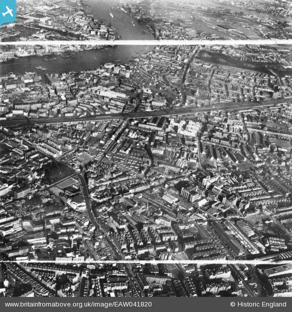
EAW041820 ENGLAND (1952). Grange Road and environs, Bermondsey, 1952. This image has been produced from a print marked by Aerofilms Ltd for photo editing.
© Hawlfraint cyfranwyr OpenStreetMap a thrwyddedwyd gan yr OpenStreetMap Foundation. 2026. Trwyddedir y gartograffeg fel CC BY-SA.
Delweddau cyfagos (15)
Manylion
| Pennawd | [EAW041820] Grange Road and environs, Bermondsey, 1952. This image has been produced from a print marked by Aerofilms Ltd for photo editing. |
| Cyfeirnod | EAW041820 |
| Dyddiad | 5-March-1952 |
| Dolen | |
| Enw lle | BERMONDSEY |
| Plwyf | |
| Ardal | |
| Gwlad | ENGLAND |
| Dwyreiniad / Gogleddiad | 533644, 179291 |
| Hydred / Lledred | -0.074539067260289, 51.496257878258 |
| Cyfeirnod Grid Cenedlaethol | TQ336793 |


![[EAW041820] Grange Road and environs, Bermondsey, 1952. This image has been produced from a print marked by Aerofilms Ltd for photo editing.](http://britainfromabove.org.uk/sites/all/libraries/aerofilms-images/public/100x100/EAW/041/EAW041820.jpg)
![[EAW041823] Grange Road and environs, Bermondsey, 1952. This image has been produced from a print marked by Aerofilms Ltd for photo editing.](http://britainfromabove.org.uk/sites/all/libraries/aerofilms-images/public/100x100/EAW/041/EAW041823.jpg)
![[EAW041817] Grange Road and environs, Bermondsey, 1952. This image was marked by Aerofilms Ltd for photo editing.](http://britainfromabove.org.uk/sites/all/libraries/aerofilms-images/public/100x100/EAW/041/EAW041817.jpg)
![[EAW041818] Grange Road and environs, Bermondsey, 1952. This image was marked by Aerofilms Ltd for photo editing.](http://britainfromabove.org.uk/sites/all/libraries/aerofilms-images/public/100x100/EAW/041/EAW041818.jpg)
![[EAW041821] Southwark Park Road, Grange Road and environs, Bermondsey, 1952. This image has been produced from a print marked by Aerofilms Ltd for photo editing.](http://britainfromabove.org.uk/sites/all/libraries/aerofilms-images/public/100x100/EAW/041/EAW041821.jpg)
![[EAW041815] Grange Road and environs, Bermondsey, 1952. This image was marked by Aerofilms Ltd for photo editing.](http://britainfromabove.org.uk/sites/all/libraries/aerofilms-images/public/100x100/EAW/041/EAW041815.jpg)
![[EAW041816] Grange Road and environs, Bermondsey, 1952. This image was marked by Aerofilms Ltd for photo editing.](http://britainfromabove.org.uk/sites/all/libraries/aerofilms-images/public/100x100/EAW/041/EAW041816.jpg)
![[EAW041824] Grange Road and environs, Bermondsey, 1952. This image has been produced from a print marked by Aerofilms Ltd for photo editing.](http://britainfromabove.org.uk/sites/all/libraries/aerofilms-images/public/100x100/EAW/041/EAW041824.jpg)
![[EAW041826] Southwark Park Road, Grange Road and environs, Bermondsey, 1952. This image has been produced from a print marked by Aerofilms Ltd for photo editing.](http://britainfromabove.org.uk/sites/all/libraries/aerofilms-images/public/100x100/EAW/041/EAW041826.jpg)
![[EAW041813] Grange Road and environs, Bermondsey, 1952. This image was marked by Aerofilms Ltd for photo editing.](http://britainfromabove.org.uk/sites/all/libraries/aerofilms-images/public/100x100/EAW/041/EAW041813.jpg)
![[EAW041819] Grange Road and environs, Bermondsey, 1952. This image was marked by Aerofilms Ltd for photo editing.](http://britainfromabove.org.uk/sites/all/libraries/aerofilms-images/public/100x100/EAW/041/EAW041819.jpg)
![[EPW055345] A cityscape over Bermondsey looking towards Southwark Park, Bermondsey, 1937](http://britainfromabove.org.uk/sites/all/libraries/aerofilms-images/public/100x100/EPW/055/EPW055345.jpg)
![[EAW021722] A cityscape over central London, Bermondsey, from the south-east, 1949. This image has been produced from a print.](http://britainfromabove.org.uk/sites/all/libraries/aerofilms-images/public/100x100/EAW/021/EAW021722.jpg)
![[EAW041822] Grange Road and environs, Bermondsey, 1952. This image has been produced from a print marked by Aerofilms Ltd for photo editing.](http://britainfromabove.org.uk/sites/all/libraries/aerofilms-images/public/100x100/EAW/041/EAW041822.jpg)
![[EAW041814] Grange Road and environs, Bermondsey, 1952. This image was marked by Aerofilms Ltd for photo editing.](http://britainfromabove.org.uk/sites/all/libraries/aerofilms-images/public/100x100/EAW/041/EAW041814.jpg)
