
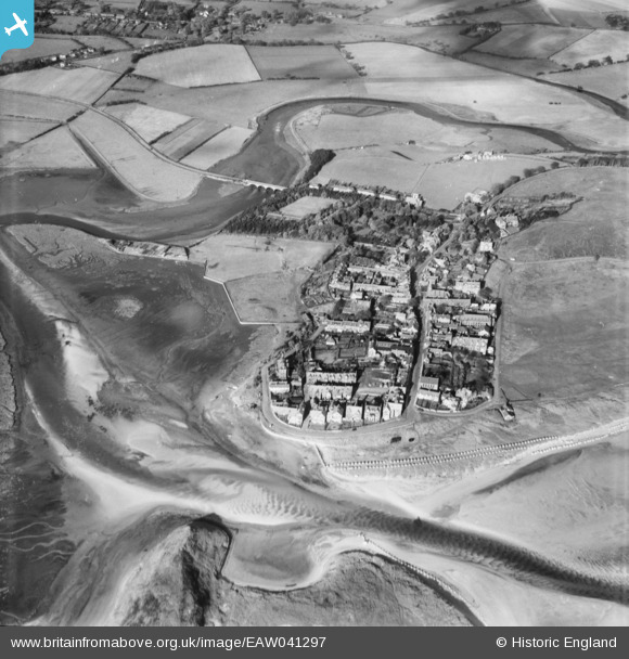
EAW041297 ENGLAND (1951). The village and mouth of the River Aln, Alnmouth, 1951
© Hawlfraint cyfranwyr OpenStreetMap a thrwyddedwyd gan yr OpenStreetMap Foundation. 2026. Trwyddedir y gartograffeg fel CC BY-SA.
Delweddau cyfagos (6)
EAW041297

EAW041296

EPW038807

EPW038804

EPW038806

EPW038805

Manylion
| Pennawd | [EAW041297] The village and mouth of the River Aln, Alnmouth, 1951 |
| Cyfeirnod | EAW041297 |
| Dyddiad | 12-November-1951 |
| Dolen | |
| Enw lle | ALNMOUTH |
| Plwyf | ALNMOUTH |
| Ardal | |
| Gwlad | ENGLAND |
| Dwyreiniad / Gogleddiad | 424538, 610487 |
| Hydred / Lledred | -1.612622737629, 55.38770629366 |
| Cyfeirnod Grid Cenedlaethol | NU245105 |
Pinnau

pillboxhunter |
Monday 6th of November 2023 05:34:53 PM | |
|
pillboxhunter |
Monday 6th of November 2023 05:33:52 PM | |
|
redmist |
Saturday 29th of April 2023 09:00:08 PM | |

Matt Aldred edob.mattaldred.com |
Monday 8th of March 2021 01:23:10 PM | |
|
Matt Aldred edob.mattaldred.com |
Monday 8th of March 2021 01:22:24 PM | |
|
Matt Aldred edob.mattaldred.com |
Monday 8th of March 2021 01:22:11 PM | |
|
redmist |
Saturday 2nd of November 2019 11:41:36 PM | |

melgibbs |
Friday 4th of November 2016 07:34:32 PM | |
|
cptpies |
Tuesday 20th of May 2014 02:01:54 PM | |
|
cptpies |
Tuesday 20th of May 2014 02:01:38 PM |
Cyfraniadau Grŵp

Coastal Defences Alnmouth. |
cptpies |
Tuesday 20th of May 2014 02:02:38 PM |